IMAGES TAKEN NEAR TO
Rackham Drive, LUTON, LU3 2AF
Introduction
This page details the photographs taken nearby to Rackham Drive, LU3 2AF by members of the Geograph project.
The Geograph project started in 2005 with the aim of publishing, organising and preserving representative images for every square kilometre of Great Britain, Ireland and the Isle of Man.

There are currently over 7.5m images from over14,400 individuals and you can help contribute to the project by visiting https://www.geograph.org.uk
Image Map
Images are licensed for reuse under creativecommons.org/licenses/by-sa/2.0
Notes
- Clicking on the map will re-center to the selected point.
- The higher the marker number, the further away the image location is from the centre of the postcode.
Image Listing (6 Images Found)
Images are licensed for reuse under creativecommons.org/licenses/by-sa/2.0
Image
Details
Distance
2
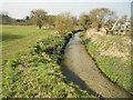
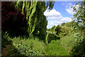
River Lee in Fallowfield, Biscot
The River Lee is crystal clear here as it flows through the Fallowfield County Wildlife Site. The field on the left is an ancient meadow.
Image: © Nigel Cox
Taken: 12 Mar 2016
0.16 miles
4
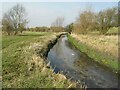
River Lee in Fallowfield, Biscot
The River Lee is crystal clear here as it flows through the Fallowfield County Wildlife Site. The field on the left is an ancient meadow.
Image: © Nigel Cox
Taken: 12 Mar 2016
0.21 miles

6
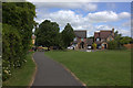
Path by the River Lea
This path leads to an area of open ground by the River Lea with allotments to the north and housing to the south.
Image: © Robert Eva
Taken: 16 Jun 2017
0.23 miles