IMAGES TAKEN NEAR TO
Pepsal End, LUTON, LU1 4LH
Introduction
This page details the photographs taken nearby to Pepsal End, LU1 4LH by members of the Geograph project.
The Geograph project started in 2005 with the aim of publishing, organising and preserving representative images for every square kilometre of Great Britain, Ireland and the Isle of Man.

There are currently over 7.5m images from over14,400 individuals and you can help contribute to the project by visiting https://www.geograph.org.uk
Image Map
Images are licensed for reuse under creativecommons.org/licenses/by-sa/2.0
Notes
- Clicking on the map will re-center to the selected point.
- The higher the marker number, the further away the image location is from the centre of the postcode.
Image Listing (15 Images Found)
Images are licensed for reuse under creativecommons.org/licenses/by-sa/2.0
Image
Details
Distance
1
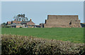
Pepsalend Farm
Taken from the same place as Image] zoomed in on Pepsalend Farm in the next gridsquare to the north. See also Image] and Image]
Image: © Rob Farrow
Taken: 29 Mar 2012
0.06 miles
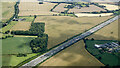
2
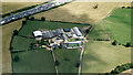
Pepsalend farm from the air
The M1 motorway is in the top right corner.
Image: © Thomas Nugent
Taken: 17 Jul 2024
0.07 miles
3
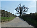
Drive to Pepsalend Farm
This drive leads off Pepsal End Road to the farm of the same name. See also Image] and to see the farm Image]
Image: © Rob Farrow
Taken: 29 Mar 2012
0.09 miles
4
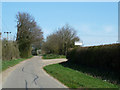
Pepsal End Road past Pepsalend Farm
Presumably this is Pepsal End - as Pepsal End Lane is seen here passing the drive up to Pepsalend Farm (see Image]) See also Image] for a view of the farm.
Image: © Rob Farrow
Taken: 29 Mar 2012
0.14 miles
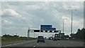
6
The M1 motorway at Chalk Wood
Chalk Wood is close to the motorway on the left, with Heavens Wood beyond. Pepsalend Farm is on the right.
Image: © Thomas Nugent
Taken: 17 Jul 2024
0.16 miles
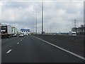
9
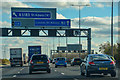
Borough of Dacorum : M1 Motorway
The M1 Motorway between Junction 10 (Pepperstock) and Junction 9 (Friar's Wash).
Image: © Lewis Clarke
Taken: 3 Oct 2018
0.17 miles
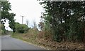
10
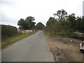
Pepsal End Lane, Pepperstock
The path entrance on the left has been cleared within the last year and had the new fence and barriers put up.
Image: © David Howard
Taken: 19 Jul 2017
0.17 miles