IMAGES TAKEN NEAR TO
Front Street, LUTON, LU1 4BS
Introduction
This page details the photographs taken nearby to Front Street, LU1 4BS by members of the Geograph project.
The Geograph project started in 2005 with the aim of publishing, organising and preserving representative images for every square kilometre of Great Britain, Ireland and the Isle of Man.

There are currently over 7.5m images from over14,400 individuals and you can help contribute to the project by visiting https://www.geograph.org.uk
Image Map
Images are licensed for reuse under creativecommons.org/licenses/by-sa/2.0
Notes
- Clicking on the map will re-center to the selected point.
- The higher the marker number, the further away the image location is from the centre of the postcode.
Image Listing (19 Images Found)
Images are licensed for reuse under creativecommons.org/licenses/by-sa/2.0
Image
Details
Distance
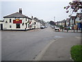
1
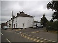
Front Street at the junction of New Street
Image: © David Howard
Taken: 19 Jul 2017
0.06 miles
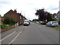
3
Front Street, Pepperstock
At the junction with New Street
Image: © Geographer
Taken: 9 Jan 2013
0.07 miles
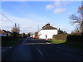
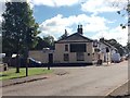
5
Slip End: Front Street
Viewed looking from the B4540 Markyate Road / Church Road crossroads, with the Rising Sun Public House on the left.
Image: © Nigel Cox
Taken: 13 May 2006
0.09 miles
8
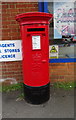
Elizabeth II postbox on Markyate Road, Slip End
Postbox No. LU1 202.
See Image] for context.
Image: © JThomas
Taken: 3 Aug 2019
0.12 miles
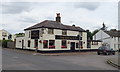
9
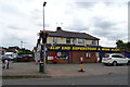
Slip End Superstore & Wine Mart
On Markyate Road.
Showing position of Postbox No. LU1 202.
See Image] for postbox.
Image: © JThomas
Taken: 3 Aug 2019
0.13 miles
10

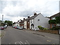
Sign for the Rising Sun, Slip End
See Image] for context.
Image: © JThomas
Taken: 3 Aug 2019
0.13 miles