IMAGES TAKEN NEAR TO
Luton Road, LUTON, LU1 4AD
Introduction
This page details the photographs taken nearby to Luton Road, LU1 4AD by members of the Geograph project.
The Geograph project started in 2005 with the aim of publishing, organising and preserving representative images for every square kilometre of Great Britain, Ireland and the Isle of Man.

There are currently over 7.5m images from over14,400 individuals and you can help contribute to the project by visiting https://www.geograph.org.uk
Image Map
Images are licensed for reuse under creativecommons.org/licenses/by-sa/2.0
Notes
- Clicking on the map will re-center to the selected point.
- The higher the marker number, the further away the image location is from the centre of the postcode.
Image Listing (12 Images Found)
Images are licensed for reuse under creativecommons.org/licenses/by-sa/2.0
Image
Details
Distance
1
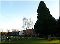
Caddington Union Chapel from All Saints churchyard
The white building in the background here is the Union Chapel (Luton Branch) dating from 1846 with the modern Baptist Church to its left (see Image] for closer view).
The tall yew in the churchyard leans slightly towards the gravestones which cluster at the eastern end of the churchyard of All Saints.
Image: © Rob Farrow
Taken: 12 Jan 2012
0.16 miles
2
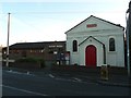
Union Chapel and Baptist Church, Caddington
The white building has a plaque above its door stating that it is "Luton Branch, Union Chapel, 1846" - the Baptist Church immediately to its left is of course of much more recent date. Whether the two are effectively the same institution I don't know.
Image: © Rob Farrow
Taken: 12 Jan 2012
0.17 miles
3
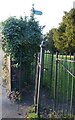
Footpath gateway in churchyard, Caddington
Quite unusually a public footpath strikes straight across the churchyard of All Saints, Caddington. The Victorian swing gate seen here allows access to the path which goes due north (with a kink in it according to the map) to the east of the church.
Image: © Rob Farrow
Taken: 12 Jan 2012
0.18 miles
4
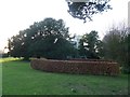
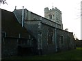
All Saints, Caddington in its churchyard
From the east, All Saints, Caddington is all but hidden by an array of yews.
The neat brown hedges nearer the camera surround a garden of rest separate from the main graveyard which lies behind the photographer to the east.
Other views: Image] Image] Image]
Image: © Rob Farrow
Taken: 12 Jan 2012
0.18 miles
5
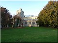
All Saints, Caddington - rear view
The less often seen side of All Saints, Caddington showing the North Aisle and beyond it the C15th tower. The vestry, part of which can be seen nearest the camera was added in 1876 at the time of the major restoration of the church's fabric.
Image: © Rob Farrow
Taken: 12 Jan 2012
0.19 miles
6
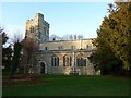
All Saints, Caddington from the pavement
All Saints, Caddington, taken from the pavement of Luton Road looking over the church wall. A closer view here Image]
Image: © Rob Farrow
Taken: 12 Jan 2012
0.20 miles
7
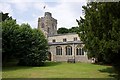
All Saints, Caddington
Taken from just inside the churchyard this is a view of the southern façade of All Saints, Caddington catching the low winter sun. The churchyard here is quite unusual in that virtually all its gravestones are situated well to the east of the church building, giving this clear green uncluttered lawn before the church.
A slightly wider-angle view here Image]
Image: © Rob Farrow
Taken: 12 Jan 2012
0.20 miles
9
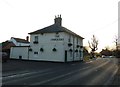
The Chequers pub, Caddington
The Chequers Public House is on Luton Road in Caddington. It serves generous helpings of good pub food in my experience ! It is situated directly opposite Image]
Image: © Rob Farrow
Taken: 12 Jan 2012
0.21 miles
10
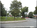
Hyde Road at the junction of Luton Road
Image: © David Howard
Taken: 19 Jul 2017
0.23 miles