IMAGES TAKEN NEAR TO
Cardigan Street, LUTON, LU1 1RY
Introduction
This page details the photographs taken nearby to Cardigan Street, LU1 1RY by members of the Geograph project.
The Geograph project started in 2005 with the aim of publishing, organising and preserving representative images for every square kilometre of Great Britain, Ireland and the Isle of Man.

There are currently over 7.5m images from over14,400 individuals and you can help contribute to the project by visiting https://www.geograph.org.uk
Image Map
Images are licensed for reuse under creativecommons.org/licenses/by-sa/2.0
Notes
- Clicking on the map will re-center to the selected point.
- The higher the marker number, the further away the image location is from the centre of the postcode.
Image Listing (100 Images Found)
Images are licensed for reuse under creativecommons.org/licenses/by-sa/2.0
Image
Details
Distance
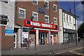
2
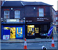
New Bedford Road
Webbs Newsagent and Moda Hairdressing, at the corner of Inkerman Street.
Image: © Thomas Nugent
Taken: 18 Nov 2011
0.06 miles
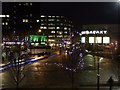
3
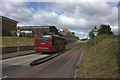
Guided Busway, Luton
The main continuous (and guided) section of the Luton & Dunstable Busway commences at this point which is just to the west of New Bedford Road in Luton Town Centre and runs to a point just east of Dunstable Town Centre. It comprises two running tracks bounded by raised kerbs with the cycling track that can be seen on the right. The two bits of the Busway at each end are not guided and are merely sections of road reserved for buses.
Image: © David Kemp
Taken: 26 Oct 2013
0.06 miles
4
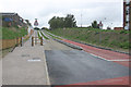
Former railway line at New Bedford Road
A railway bridge once crossed the road here. The line has been recently excavated in preparation for the creation of a guided busway.
Image: © Thomas Nugent
Taken: 18 Nov 2011
0.07 miles
6
New Bedford Road
At the corner of Gordon Street.
Image: © Thomas Nugent
Taken: 18 Nov 2011
0.10 miles
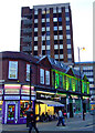
7
Luton Town Centre
Looking towards the Galaxy Centre from The Arndale shopping mall.
Image: © Thomas Nugent
Taken: 9 Dec 2008
0.10 miles
8
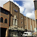
Art Deco in Luton ? former Ritz Cinema, Gordon Street
It is not shown as such until an OS map of 1960, and as a half-vacant site on a small-scale map of 1938. Beautiful relief sculpture above the window was impossible to photograph from the street Image It is now occupied by Liquid and Envy – clubs, perhaps.
Image: © Robin Stott
Taken: 24 Feb 2017
0.10 miles
9

Art Deco in Luton ??relief sculpture above window, former Ritz Cinema, Gordon Street
More of the building is seen in Image
Image: © Robin Stott
Taken: 24 Feb 2017
0.11 miles
10
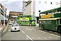
Bridge Street, Luton ? 1972
Now fully pedestrianised it was then still a major thoroughfare in the town centre.
The bus in the centre is turning into the former bus station, now St George's Square. It is a former Luton Corporation Albion Lowlander with East Lancs bodywork. Luton Corporation sold its bus undertaking to the local National Bus Company subsidiary, United Counties, in 1970 on the expiry of a local route sharing agreement in the area, thereby introducing a significant number of non-standard vehicles into the UC fleet.
This is one of a series of views featuring buses in the 60s, 70s, and 80s.
http://www.geograph.org.uk/search.php?i=2114547&displayclass=slide
Image: © Alan Murray-Rust
Taken: 8 Apr 1972
0.11 miles