IMAGES TAKEN NEAR TO
Mersey Place, Liverpool Road, LUTON, LU1 1HH
Introduction
This page details the photographs taken nearby to Mersey Place, Liverpool Road, LU1 1HH by members of the Geograph project.
The Geograph project started in 2005 with the aim of publishing, organising and preserving representative images for every square kilometre of Great Britain, Ireland and the Isle of Man.

There are currently over 7.5m images from over14,400 individuals and you can help contribute to the project by visiting https://www.geograph.org.uk
Image Map
Images are licensed for reuse under creativecommons.org/licenses/by-sa/2.0
Notes
- Clicking on the map will re-center to the selected point.
- The higher the marker number, the further away the image location is from the centre of the postcode.
Image Listing (43 Images Found)
Images are licensed for reuse under creativecommons.org/licenses/by-sa/2.0
Image
Details
Distance
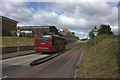
1
Junction of Telford Way and Dunstable Road
Image: © David Howard
Taken: 17 Aug 2011
0.03 miles
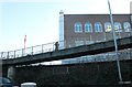
2
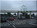
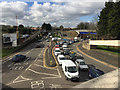
Luton: Footbridge over the ring road
The three-armed footbridge is a well-known landmark to anyone who has driven around Luton's ring road, and shows up nicely on the Ordnance Survey 1:25,000 scale mapping...
Image: © Nigel Cox
Taken: 25 Jun 2006
0.09 miles
3
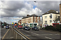
Five shops with flats above, formerly Victoria Villas, 8-16 Dunstable Road, Luton
The older 3-storey block in the centre of the photo is named rather oddly Victoria Villas on a 1:500 map of 1880. It appears to have always been so, and has not changed since apart from the insertion of shops, the nearest of which is on the corner of Cardigan Street. There were a further five properties immediately to the northwest named Brighton Terrace, nos 12-26, houses with long rear extensions. They appear to have been replaced by 20th-century development perhaps as a result of the widening and re-alignment of Dunstable Road. The view is from the pedestrian crossing at Inkerman Street and Cardiff Road.
Image: © Robin Stott
Taken: 24 Feb 2017
0.09 miles
4
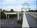
Looking east from the three-way footbridge, Luton
On the left, Hatters Way A5065 towards Dunstable. On the right, Dunstable Road A505 which connects to the M1 at Junction 11. Sailing over it, supported by the blue girder, is the guided busway to Dunstable's industrial estates and town centre. The view is from somewhere on Image
Image: © Robin Stott
Taken: 24 Feb 2017
0.09 miles
6

Royal Mail offices on Dunstable Road, Luton
Image: © David Howard
Taken: 9 Jan 2022
0.11 miles
7
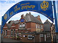
Luton: Guru Nanak Gurdwara Sikh Temple
A former school building in Dallow Road converted for use as a Sikh Temple. The Temple's website is here http://www.gngluton.com/
Image: © Nigel Cox
Taken: 25 Jun 2006
0.11 miles
9
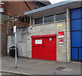
Postboxes, Luton Sorting Office, Dunstable Road
Postbox No. LU1 231.
Image: © JThomas
Taken: 3 Aug 2019
0.11 miles
10
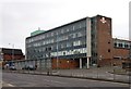
Royal Mail Delivery Office
Built 1957 to the designs of Ministry of Works architect Thomas Winterburn. Greatly influenced by the prevailing modernist architecture of the day (inspired by the work of Swiss architect Le Corbusier).
Image: © Jim Osley
Taken: 21 Mar 2015
0.12 miles