IMAGES TAKEN NEAR TO
Wells Promenade, ILKLEY, LS29 9LG
Introduction
This page details the photographs taken nearby to Wells Promenade, LS29 9LG by members of the Geograph project.
The Geograph project started in 2005 with the aim of publishing, organising and preserving representative images for every square kilometre of Great Britain, Ireland and the Isle of Man.

There are currently over 7.5m images from over14,400 individuals and you can help contribute to the project by visiting https://www.geograph.org.uk
Image Map
Images are licensed for reuse under creativecommons.org/licenses/by-sa/2.0
Notes
- Clicking on the map will re-center to the selected point.
- The higher the marker number, the further away the image location is from the centre of the postcode.
Image Listing (428 Images Found)
Images are licensed for reuse under creativecommons.org/licenses/by-sa/2.0
Image
Details
Distance
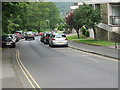
1
Wells Road - looking towards Station Road
Image: © Betty Longbottom
Taken: 30 Jul 2014
0.01 miles
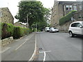
7
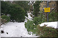
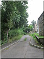
Path to Wells Walk, Ilkley
The path connects Wells Promenade with Wells Walk, names that conjure up an image of the spa town in its fashionable heyday. The path is no doubt even more slippery than usual following exceptionally heavy snowfall for late March.
Image: © Stephen McKay
Taken: 25 Mar 2013
0.05 miles
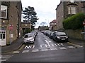
8
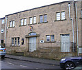
Ilkley Toy Museum - Whitton Croft Road
Image: © Betty Longbottom
Taken: 8 Dec 2009
0.05 miles