IMAGES TAKEN NEAR TO
Moorside Lane, ILKLEY, LS29 9JY
Introduction
This page details the photographs taken nearby to Moorside Lane, LS29 9JY by members of the Geograph project.
The Geograph project started in 2005 with the aim of publishing, organising and preserving representative images for every square kilometre of Great Britain, Ireland and the Isle of Man.

There are currently over 7.5m images from over14,400 individuals and you can help contribute to the project by visiting https://www.geograph.org.uk
Image Map (Loading...)


Getting Data...Please wait
Leaflet Map data © OpenStreetMap
Images are licensed for reuse under creativecommons.org/licenses/by-sa/2.0
Notes
- Clicking on the map will re-center to the selected point.
- The higher the marker number, the further away the image location is from the centre of the postcode.
Image Listing (7 Images Found)
Images are licensed for reuse under creativecommons.org/licenses/by-sa/2.0
Image
Details
Distance
1
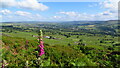
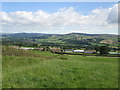
Cragg House from Piper's Crag, Rombalds Moor
Image: © Colin Park
Taken: 22 Jun 2021
0.01 miles
3
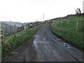
Moorside Lane near to Cragg House
Looking south-eastward.
Image: © Peter Wood
Taken: 14 Jan 2019
0.05 miles
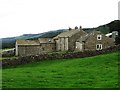
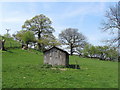
4
Crag House Farm
Approaching the farm along a track from the east.
Image: © Chris Heaton
Taken: 20 Apr 2011
0.06 miles
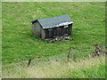
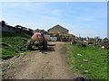
7
Hen Hut at Over Gate Croft
Deserted hen hut in a field next to Over Gate Croft - a converted farmhouse
Image: © Chris Heaton
Taken: 20 Apr 2011
0.24 miles