IMAGES TAKEN NEAR TO
Straight Lane, ILKLEY, LS29 9JU
Introduction
This page details the photographs taken nearby to Straight Lane, LS29 9JU by members of the Geograph project.
The Geograph project started in 2005 with the aim of publishing, organising and preserving representative images for every square kilometre of Great Britain, Ireland and the Isle of Man.

There are currently over 7.5m images from over14,400 individuals and you can help contribute to the project by visiting https://www.geograph.org.uk
Image Map (Loading...)


Getting Data...Please wait
Leaflet Map data © OpenStreetMap
Images are licensed for reuse under creativecommons.org/licenses/by-sa/2.0
Notes
- Clicking on the map will re-center to the selected point.
- The higher the marker number, the further away the image location is from the centre of the postcode.
Image Listing (11 Images Found)
Images are licensed for reuse under creativecommons.org/licenses/by-sa/2.0
Image
Details
Distance
1
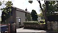
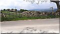
Scar Ghyll Farm on south side of Straight Lane
Ordnance Survey documents indicate that a benchmark levelled at 276.826m above Newlyn Datum was verified in 1962 on a building at the farm
Image: © Luke Shaw
Taken: 29 May 2021
0.11 miles
2
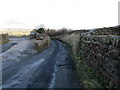
Moorside Lane at the entrance to School Wood Farm
Looking eastward.
Image: © Peter Wood
Taken: 14 Jan 2019
0.12 miles
3
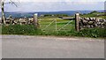
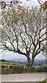
View through field gateway on east side of Straight Lane at Hodson's Farm
There is an Ordnance Survey benchmark Image on the right hand gatepost of the gateway
Image: © Roger Templeman
Taken: 29 May 2021
0.14 miles
4
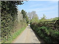
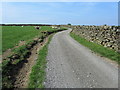
Moorside Lane
Narrow Lane on Addingham Moorside
Image: © Chris Heaton
Taken: 20 Apr 2011
0.14 miles
5
Field gateway and footpath on north side of Moorhouse Lane
Image: © Roger Templeman
Taken: 29 May 2021
0.15 miles
6
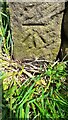
Benchmark on gatepost at field entrance on east side of Straight Lane at Hodson's Farm
Ordnance Survey cut mark benchmark described on the Bench Mark Database at www.bench-marks.org.uk/bm84037
Image: © Roger Templeman
Taken: 29 May 2021
0.16 miles
8
Access Lane from High House
The access track runs over Brocka Bank Moor to Straight Lane.
Image: © Chris Heaton
Taken: 20 Apr 2011
0.17 miles
9
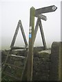
Fingerpost and stile at Hodsons Farm
The sign reads Windgate Nick (straight on) and Light Bank Lane (right).
Image: © Tim Cook
Taken: 23 Oct 2005
0.19 miles
10
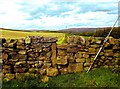
North of High House Farm
In Wharfedale.
Image: © Neil Theasby
Taken: 13 Sep 2015
0.22 miles