IMAGES TAKEN NEAR TO
Springs Lane, ILKLEY, LS29 8TG
Introduction
This page details the photographs taken nearby to Springs Lane, LS29 8TG by members of the Geograph project.
The Geograph project started in 2005 with the aim of publishing, organising and preserving representative images for every square kilometre of Great Britain, Ireland and the Isle of Man.

There are currently over 7.5m images from over14,400 individuals and you can help contribute to the project by visiting https://www.geograph.org.uk
Image Map
Images are licensed for reuse under creativecommons.org/licenses/by-sa/2.0
Notes
- Clicking on the map will re-center to the selected point.
- The higher the marker number, the further away the image location is from the centre of the postcode.
Image Listing (97 Images Found)
Images are licensed for reuse under creativecommons.org/licenses/by-sa/2.0
Image
Details
Distance
2
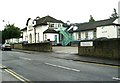
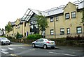
Ilkley Coronation Hospital
In Springs Lane, the hospital provides services for Airedale NHS Trust. 2005 is its centenary year.
Image: © David Spencer
Taken: 2 Oct 2005
0.05 miles
4
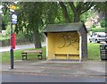
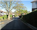
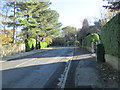
Bus Shelter - Bolling Road, Ben Rhydding
Image: © Betty Longbottom
Taken: 5 Aug 2008
0.06 miles
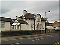
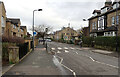
7
Springs Medical Centre - Springs Lane
Image: © Betty Longbottom
Taken: 5 Aug 2008
0.09 miles
10
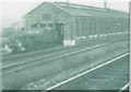
Engine shed
The old engine shed, Ilkley, in 1955. The building was finally demolished in 1960.
Image: © David Chatterton
Taken: Unknown
0.10 miles