IMAGES TAKEN NEAR TO
Vale Gardens, ILKLEY, LS29 8LB
Introduction
This page details the photographs taken nearby to Vale Gardens, LS29 8LB by members of the Geograph project.
The Geograph project started in 2005 with the aim of publishing, organising and preserving representative images for every square kilometre of Great Britain, Ireland and the Isle of Man.

There are currently over 7.5m images from over14,400 individuals and you can help contribute to the project by visiting https://www.geograph.org.uk
Image Map
Images are licensed for reuse under creativecommons.org/licenses/by-sa/2.0
Notes
- Clicking on the map will re-center to the selected point.
- The higher the marker number, the further away the image location is from the centre of the postcode.
Image Listing (69 Images Found)
Images are licensed for reuse under creativecommons.org/licenses/by-sa/2.0
Image
Details
Distance
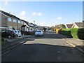
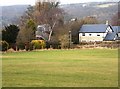
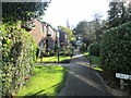
1
Grange Close, Ilkley
Grange Close seen from the junction with Valley Drive; snow-covered Ilkley Moor can be seen in the distance.
Image: © Stephen McKay
Taken: 25 Mar 2013
0.04 miles
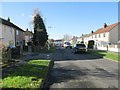
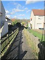
2
Field and Footbridge
The Footbridge crosses the railway line. Viewed from Bolling Road.
Image: © SMJ
Taken: 24 Jan 2009
0.05 miles
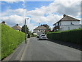
4

George VI Postbox in Ilkley.
On the corner of Mayfield Avenue and Valley Drive.
Image: © Steve Partridge
Taken: 1 Jul 2007
0.05 miles
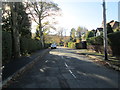
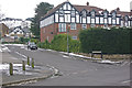
7

The Valley Dental Clinic - Valley Road
Image: © Betty Longbottom
Taken: 5 Aug 2008
0.10 miles