IMAGES TAKEN NEAR TO
Sawyers Garth, ILKLEY, LS29 0RZ
Introduction
This page details the photographs taken nearby to Sawyers Garth, LS29 0RZ by members of the Geograph project.
The Geograph project started in 2005 with the aim of publishing, organising and preserving representative images for every square kilometre of Great Britain, Ireland and the Isle of Man.

There are currently over 7.5m images from over14,400 individuals and you can help contribute to the project by visiting https://www.geograph.org.uk
Image Map (Loading...)


Getting Data...Please wait
Leaflet Map data © OpenStreetMap
Images are licensed for reuse under creativecommons.org/licenses/by-sa/2.0
Notes
- Clicking on the map will re-center to the selected point.
- The higher the marker number, the further away the image location is from the centre of the postcode.
Image Listing (184 Images Found)
Images are licensed for reuse under creativecommons.org/licenses/by-sa/2.0
Image
Details
Distance
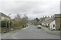
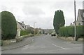
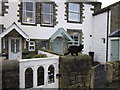
4
Western part of Church Street, Addingham
Seen from its junction with North Street.
Image: © Richard Vince
Taken: 28 May 2022
0.04 miles

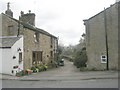
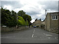
7
Old School & Old Schoolhouse - North Street
Image: © Betty Longbottom
Taken: 2 Mar 2009
0.05 miles
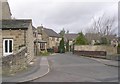
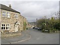
8
The Dales Way
#34, houses on North Street, Addingham.
Image: © Ian S
Taken: 19 Oct 2012
0.05 miles