IMAGES TAKEN NEAR TO
High Mill, High Mill Lane, ILKLEY, LS29 0RY
Introduction
This page details the photographs taken nearby to High Mill, High Mill Lane, LS29 0RY by members of the Geograph project.
The Geograph project started in 2005 with the aim of publishing, organising and preserving representative images for every square kilometre of Great Britain, Ireland and the Isle of Man.

There are currently over 7.5m images from over14,400 individuals and you can help contribute to the project by visiting https://www.geograph.org.uk
Image Map (Loading...)


Getting Data...Please wait
Leaflet Map data © OpenStreetMap
Images are licensed for reuse under creativecommons.org/licenses/by-sa/2.0
Notes
- Clicking on the map will re-center to the selected point.
- The higher the marker number, the further away the image location is from the centre of the postcode.
Image Listing (77 Images Found)
Images are licensed for reuse under creativecommons.org/licenses/by-sa/2.0
Image
Details
Distance
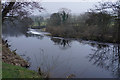
1
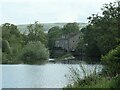
High Mill, Addingham and its weir across the Wharfe
The weir was built for a water-powered medieval corn mill. In 1788 the corn mill was extended to create a water-powered spinning mill as well. Over time the yarns spun here included cotton, silk and worsted. The corn mill closed in the 1870s and the textile mill in 1967. After a period as a light engineering workshop, the former mill was converted into eight houses in 1984.
Image: © Christine Johnstone
Taken: 28 May 2023
0.00 miles
2
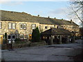
High Mill, Addingham
now converted into housing
Image: © Malcolm Street
Taken: 16 Dec 2005
0.02 miles
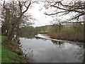
4
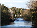
High Mill at Addingham.
High Mill and weir viewed from the Addingham suspension footbridge which is about 300m downstream.
Image: © David Rogers
Taken: 31 Oct 2008
0.02 miles
5

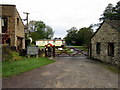
Olicana Caravan Park, Addingham
Caravan site beside the River Wharfe at High Mill, Addingham. The main thoroughfare in the complex carries the Dales Way long distance footpath
Image: © Chris Heaton
Taken: 20 Apr 2011
0.05 miles
6
Weir on the River Wharfe
Cold and dull wintery conditions near Addingham.
Image: © Bill Boaden
Taken: 27 Jan 2017
0.05 miles
7
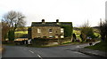
Mill Lane Top, Addingham
House dating from 1812 at the corner of High Mill Lane and Bolton Road.
Image: © David Rogers
Taken: 9 Feb 2010
0.06 miles
8
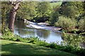
Weir across the River Wharfe at Winebeck Farm Addingham
On the route of the Dale Way long distance footpath
Image: © John Sparshatt
Taken: 14 May 2008
0.06 miles
9
Weir on the River Wharfe near Addingham
Image: © John Slater
Taken: 23 Jan 2016
0.06 miles
10
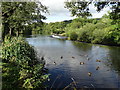
Weir and ducks on The River Wharfe
Near to High Mill, Addingham
Image: © Neil Theasby
Taken: 12 Sep 2015
0.06 miles