IMAGES TAKEN NEAR TO
Ilkley Road, ILKLEY, LS29 0RR
Introduction
This page details the photographs taken nearby to Ilkley Road, LS29 0RR by members of the Geograph project.
The Geograph project started in 2005 with the aim of publishing, organising and preserving representative images for every square kilometre of Great Britain, Ireland and the Isle of Man.

There are currently over 7.5m images from over14,400 individuals and you can help contribute to the project by visiting https://www.geograph.org.uk
Image Map (Loading...)


Getting Data...Please wait
Leaflet Map data © OpenStreetMap
Images are licensed for reuse under creativecommons.org/licenses/by-sa/2.0
Notes
- Clicking on the map will re-center to the selected point.
- The higher the marker number, the further away the image location is from the centre of the postcode.
Image Listing (35 Images Found)
Images are licensed for reuse under creativecommons.org/licenses/by-sa/2.0
Image
Details
Distance
1
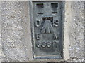
Ordnance Survey Flush Bracket G3617
This can be found on a barn wall at Low Holme House Farm.
For more details see : http://www.bench-marks.org.uk/bm15658
Image: © Peter Wood
Taken: 21 Apr 2012
0.01 miles
2
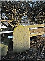
Old Milestone by the former A65, Ilkley Road, Addingham parish
Carved stone post by the UC road (was A65), in parish of ADDINGHAM (BRADFORD District), Ilkley Road, old road into Addingham, 150m Southeast of Low Holme House, at wall end, under hedge just North of Milestone YW_SKOT07 Image, on North side of road. Erected by the Skipton & Otley turnpike trust in the 18th century.
Inscription once read:-
(Skipton)
(7)
(Otley)
(8)
Milestone Society National ID: YW_SKOT07a.
Image: © JW
Taken: 6 Nov 2008
0.09 miles
4

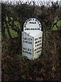
Old Milestone by the former A65, Ilkley Road, Addingham parish
Metal plate attached to stone post by the UC road (was A65), in parish of ADDINGHAM (BRADFORD District), Ilkley Road, old road into Addingham, 150m Southeast of Low Holme House, in verge under hedge near '40' sign, on North side of road, just South of Milestone YW_SKOT07a Image West Riding iron casting, erected by the County Council in the 19th century.
Inscription reads:-
: ILKLEY / 2¼ MILES / OTLEY / 8½ MILES : : SKIPTON & OTLEY / ROAD / ADDINGHAM : : BOLTON / BRIDGE / 3 MILES / SKIPTON / 7 MILES :
Grade II listed.
List Entry Number: 1133420 https://historicengland.org.uk/listing/the-list/list-entry/1133420
Milestone Society National ID: YW_SKOT07.
Image: © C Minto
Taken: 15 Sep 2002
0.09 miles
5
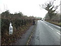
Ilkley Road
Looking south east.
See Image] for milestone.
Image: © JThomas
Taken: 17 Dec 2016
0.10 miles
7

Passing Hallcroft Hall on The Dales Way
Image: © Basher Eyre
Taken: 12 Sep 2014
0.17 miles
8
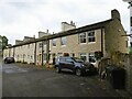
Terrace housing
On Low Mill Lane between Addingham and Low Mill Village. Low Mill Lane is used by the named walking route Dales Way.
Image: © Kevin Waterhouse
Taken: 7 Aug 2024
0.17 miles
9
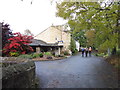
The Dales Way
#26, Low Mill Lane towards Addingham.
Image: © Ian S
Taken: 19 Oct 2012
0.17 miles
10

Tree in winter garb
Looking from Low Mill Lane away from the River Wharfe, on a dull winter day.
Image: © Bill Boaden
Taken: 27 Jan 2017
0.17 miles