IMAGES TAKEN NEAR TO
Brumfitt Hill, ILKLEY, LS29 0PF
Introduction
This page details the photographs taken nearby to Brumfitt Hill, LS29 0PF by members of the Geograph project.
The Geograph project started in 2005 with the aim of publishing, organising and preserving representative images for every square kilometre of Great Britain, Ireland and the Isle of Man.

There are currently over 7.5m images from over14,400 individuals and you can help contribute to the project by visiting https://www.geograph.org.uk
Image Map
Images are licensed for reuse under creativecommons.org/licenses/by-sa/2.0
Notes
- Clicking on the map will re-center to the selected point.
- The higher the marker number, the further away the image location is from the centre of the postcode.
Image Listing (194 Images Found)
Images are licensed for reuse under creativecommons.org/licenses/by-sa/2.0
Image
Details
Distance
5
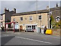
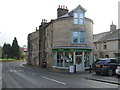
The Old School - Main Street
Originally built 1668 - rebuilt with second storey 1805 - now used as Parish Rooms & Library.
Image: © Betty Longbottom
Taken: 13 Oct 2015
0.02 miles
7
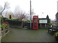
Telephone box and tourist information board, Addingham
Image: © JThomas
Taken: 17 Dec 2016
0.02 miles
9
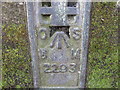
Ordnance Survey Flush Bracket 2293
This bracket can be found on Town Beck Bridge in Addingham.
For more detail see : http://www.bench-marks.org.uk/bm2454
Image: © Peter Wood
Taken: 21 Apr 2012
0.02 miles