IMAGES TAKEN NEAR TO
Crossbank Road, ILKLEY, LS29 0LB
Introduction
This page details the photographs taken nearby to Crossbank Road, LS29 0LB by members of the Geograph project.
The Geograph project started in 2005 with the aim of publishing, organising and preserving representative images for every square kilometre of Great Britain, Ireland and the Isle of Man.

There are currently over 7.5m images from over14,400 individuals and you can help contribute to the project by visiting https://www.geograph.org.uk
Image Map (Loading...)


Getting Data...Please wait
Leaflet Map data © OpenStreetMap
Images are licensed for reuse under creativecommons.org/licenses/by-sa/2.0
Notes
- Clicking on the map will re-center to the selected point.
- The higher the marker number, the further away the image location is from the centre of the postcode.
Image Listing (8 Images Found)
Images are licensed for reuse under creativecommons.org/licenses/by-sa/2.0
Image
Details
Distance
1
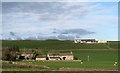
Hillside properties
The view across fields to Low White Well and Upper White Well. The upper buildings would appear to be part of a working farm, but those lower down show signs of being 'gentrified'.
Image: © Gordon Hatton
Taken: 26 Nov 2018
0.02 miles
2
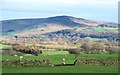
Sheep pastures above Addingham
Green pastures above Addingham with a view across lower Wharfedale towards Beamsley Beacon.
Image: © Gordon Hatton
Taken: 26 Nov 2018
0.05 miles
3
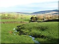
Heading for the Humber
A tiny unnamed stream heading down towards Heathness Gill and the River Wharfe.
Image: © Gordon Hatton
Taken: 26 Nov 2018
0.07 miles
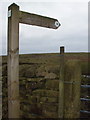
5
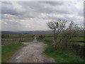
Lane over Addingham Low Moor
The old road to Skipton from Addingham, which becomes unmetalled after passing Low White Well Farm.
Image: © Chris Heaton
Taken: 3 Sep 2008
0.15 miles
6
Footpath to Woofa Bank
Looking towards Counter Hill. You have to be barking to walk this path.
Image: © Tim
Taken: 22 Feb 2006
0.16 miles
7
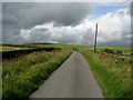
![The end [or beginning] of the tarmac](https://s0.geograph.org.uk/geophotos/05/98/81/5988140_54c59fcd_120x120.jpg)
The end [or beginning] of the tarmac
A rough, but mostly tarmacked road runs uphill from Addingham as far as the turn for Upper White Well farm, after which the next few metres are through some rather malodorous goo next to the pile of manure. The road is on the line of the old Addingham to Skipton turnpike, which came this way between 1755 and 1820, after which an easier route was followed along what is now much of the line of the A65. Local claims that this was also a Roman road have been proved wrong in recent years as Lidar images show up a line running roughly parallel with the A65.
Image: © Gordon Hatton
Taken: 26 Nov 2018
0.20 miles
8
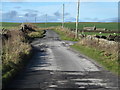
Moor Lane above Addingham
As one proceeds further up this dead end lane, so the surface becomes rougher and more potholed. Eventually tarmac gives way to a rough surface and then grass beyond the turn for Upper White Well. This is part of the old turnpike road from Addingham to Skipton and is now designated as the 'Dales High Way', a recreational route from Saltaire to Appleby.
Image: © Gordon Hatton
Taken: 26 Nov 2018
0.21 miles