
IMAGES TAKEN NEAR TO
Skipton Road, ILKLEY, LS29 0JU
Introduction
This page details the photographs taken nearby to Skipton Road, LS29 0JU by members of the Geograph project.
The Geograph project started in 2005 with the aim of publishing, organising and preserving representative images for every square kilometre of Great Britain, Ireland and the Isle of Man.

There are currently over 7.5m images from over14,400 individuals and you can help contribute to the project by visiting https://www.geograph.org.uk
Image Map
Images are licensed for reuse under creativecommons.org/licenses/by-sa/2.0
Notes
- Clicking on the map will re-center to the selected point.
- The higher the marker number, the further away the image location is from the centre of the postcode.
Image Listing (4 Images Found)
Images are licensed for reuse under creativecommons.org/licenses/by-sa/2.0
Image
Details
Distance
1
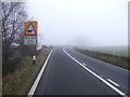
A65 towards Leeds
Looking south east beside Chelker Reservoir.
Image: © JThomas
Taken: 17 Dec 2016
0.15 miles
2
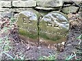
Old Boundary Marker on the A65 near Chelker Reservoir
Parish Boundary Marker formed by two similar stones side by side against a drystone wall on the southwest side of the A65, adjacent to a cattle crossing warning signal. Inscribed ES / ADDINGHAM and HD / DRAUGHTON. On the boundary of Addingham and Draughton parishes, and now between West and North Yorkshire. ESHD stands for East Staincliffe Highway District and this dates the stone between 1862 and 1894.
Milestone Society National ID: YW_ADDDRA01pb
Image: © H Jones
Taken: 5 Nov 2022
0.15 miles
4
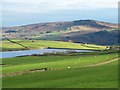
View to Chelker Reservoir
Sunlit pastures around Chelker Reservoir with Beamsley Beacon in the distance. Most of the water in the reservoir will have come via a lengthy pipeline from the reservoirs in Upper Nidderdale.
Image: © Gordon Hatton
Taken: 26 Nov 2018
0.24 miles