IMAGES TAKEN NEAR TO
Langbar, ILKLEY, LS29 0ER
Introduction
This page details the photographs taken nearby to LS29 0ER by members of the Geograph project.
The Geograph project started in 2005 with the aim of publishing, organising and preserving representative images for every square kilometre of Great Britain, Ireland and the Isle of Man.

There are currently over 7.5m images from over14,400 individuals and you can help contribute to the project by visiting https://www.geograph.org.uk
Image Map (Loading...)


Getting Data...Please wait
Leaflet Map data © OpenStreetMap
Images are licensed for reuse under creativecommons.org/licenses/by-sa/2.0
Notes
- Clicking on the map will re-center to the selected point.
- The higher the marker number, the further away the image location is from the centre of the postcode.
Image Listing (13 Images Found)
Images are licensed for reuse under creativecommons.org/licenses/by-sa/2.0
Image
Details
Distance
1
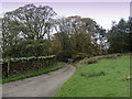
Access Drive to Currer Hall
Vehicuar and pedestrian traffic use this drive to reach Currer Hall
Image: © Chris Heaton
Taken: 2 Nov 2011
0.04 miles
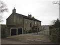
3
Rooftops of Farrand House
Hill top farm on Howber Hill, near Ilkley.
Image: © Peter Barr
Taken: 11 Nov 2010
0.18 miles
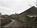
5
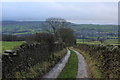
Langbar Lane
Substantial track heading south west towards Addingham. Further down the bridleway becomes very narrow, squeezing through a long trench too constrained to allow the passage of a horse.
Image: © Chris Heaton
Taken: 13 Dec 2019
0.19 miles
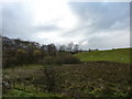
6
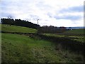
Footpath near Howber Hill
A rather soggy path following the side of a shallow 'dry' valley, which is a former glacial overflow channel. The wall in the middle distance marks the boundary of the Yorkshire Dales National Park.
Image: © Gordon Hatton
Taken: 6 Nov 2010
0.20 miles
7
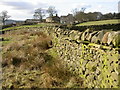
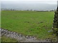
Dry Stone Wall at Langbar
Lichen-covered dry stone walls divide up the pasture close to Hardistys and Langbar, north of Ilkley. There are plenty of rabbit droppings in the tussocky grass by the side of the lane!
Image: © Derek Parkinson
Taken: 18 Feb 2006
0.20 miles
9
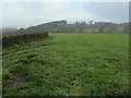
Looking towards Howber Hill
Following a footpath through pastures towards Howber Hill
Image: © Chris Heaton
Taken: 2 Nov 2011
0.22 miles
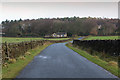
10
Hillside below Beacon Hill House
On the east side of Currer Lane. Looking through the rain towards Wharfedale.
Image: © Christine Johnstone
Taken: 22 Feb 2015
0.22 miles