IMAGES TAKEN NEAR TO
Hardings Lane, ILKLEY, LS29 0EA
Introduction
This page details the photographs taken nearby to Hardings Lane, LS29 0EA by members of the Geograph project.
The Geograph project started in 2005 with the aim of publishing, organising and preserving representative images for every square kilometre of Great Britain, Ireland and the Isle of Man.

There are currently over 7.5m images from over14,400 individuals and you can help contribute to the project by visiting https://www.geograph.org.uk
Image Map (26 Images)


Getting Data...Please wait
Leaflet Map data © OpenStreetMap
Images are licensed for reuse under creativecommons.org/licenses/by-sa/2.0
Notes
- Clicking on the map will re-center to the selected point.
- The higher the marker number, the further away the image location is from the centre of the postcode.
Image Listing (26 Images Found)
Images are licensed for reuse under creativecommons.org/licenses/by-sa/2.0
Image
Details
Distance
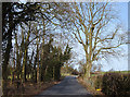
1
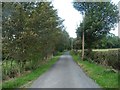
Hardings Lane, looking west past The Hollies
A county boundary. The left [south] side is in West Yorkshire, the north [right] side in North Yorkshire.
Image: © Christine Johnstone
Taken: 24 Sep 2014
0.03 miles
2
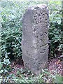
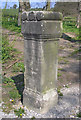
Old Milestone by Hardings Lane, Ilkley
Stone post by the UC road, in parish of Ilkley (Craven District), Hardings Lane, Ilkley, behind new fence just North of entrance to Myddleton Lodge.
Inscription reads:-
: {<-hand} / TO / KEIGH / LEY / 5 M : : TO / RIPPO / N / 15 M / {hand->} :
Grade II listed.
List Entry Number: 1393126 https://historicengland.org.uk/listing/the-list/list-entry/1393126
Surveyed
Milestone Society National ID: YN_XMIDa
Image: © Milestone Society
Taken: Unknown
0.04 miles
3
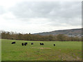
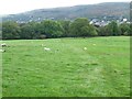
Sheep and feeder, northern slopes of Wharfedale
The sheep are ignoring the feeder, as there is plenty of pasture.
Image: © Christine Johnstone
Taken: 24 Sep 2014
0.04 miles
4
Black sheep in a field off Slates Lane
There's an element of apartheid going on here, see Image
Image: © Stephen Craven
Taken: 7 Mar 2020
0.05 miles
5
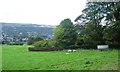
Hardings Lane, Middleton, Wharfedale
Looking north from near the entrance to Middleton Lodge to the north of Ilkley.
Image: © michael ely
Taken: 9 Feb 2008
0.05 miles
6
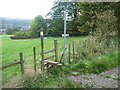
Footpath signpost and stile, south side, Hardings Lane
Leading down the valley side to Middleton Woods.
Image: © Christine Johnstone
Taken: 24 Sep 2014
0.05 miles
7
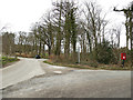
Road behind Myddleton Grange
There's a post box on the corner.
Image: © Stephen Craven
Taken: 7 Mar 2020
0.07 miles
8
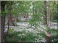
Wild garlic
This small wood is full of wild garlic or ramsons.
Image: © John Illingworth
Taken: 30 May 2015
0.07 miles
9
Roman altar stone
This stone is a copy of a Roman original found in the River Wharfe. The copy was made for William Middleton (or Middelton or Myddelton) in 1603 and the inscription at the right-hand side says this.
The main inscription is:
VERBEIAE SACRUM
CLODIUS FRONTO PRAEF COH II LINGON
This translates as "Sacred to Verbeia"
and "Clodius Fronto prefect of the second Cohort of Lingonians" had it set up.
Most opinion is that Verbeia was the river goddess of the Wharfe.
The stone was originally kept at Myddelton Lodge but was erected here a few years ago.
Image: © John Illingworth
Taken: 17 Apr 2019
0.07 miles
10
Public footpath to Middleton Woods
Heading south-east, down into Wharfedale, above Ilkley.
Image: © Christine Johnstone
Taken: 24 Sep 2014
0.07 miles