IMAGES TAKEN NEAR TO
Curly Hill, ILKLEY, LS29 0DT
Introduction
This page details the photographs taken nearby to Curly Hill, LS29 0DT by members of the Geograph project.
The Geograph project started in 2005 with the aim of publishing, organising and preserving representative images for every square kilometre of Great Britain, Ireland and the Isle of Man.

There are currently over 7.5m images from over14,400 individuals and you can help contribute to the project by visiting https://www.geograph.org.uk
Image Map (Loading...)


Getting Data...Please wait
Leaflet Map data © OpenStreetMap
Images are licensed for reuse under creativecommons.org/licenses/by-sa/2.0
Notes
- Clicking on the map will re-center to the selected point.
- The higher the marker number, the further away the image location is from the centre of the postcode.
Image Listing (22 Images Found)
Images are licensed for reuse under creativecommons.org/licenses/by-sa/2.0
Image
Details
Distance
1
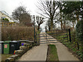
Access to Curly Hill Scout camp, Ilkley
A private track.
Image: © Stephen Craven
Taken: 7 Mar 2020
0.04 miles
2
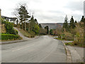
Curly Hill, Ilkley
The road lives up to its name, as it sinuously descends the hillside towards Ilkley town centre.
Image: © Stephen Craven
Taken: 7 Mar 2020
0.05 miles
3
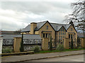
Eclectic house on Curly Hill, Ilkley
The style of the bay windows suggests early 20th century, but Google streetview shows it apparently under construction (or renovation) in 2016, so it may be later than it appears.
Image: © Stephen Craven
Taken: 7 Mar 2020
0.12 miles
4
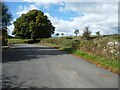
Looking west, Slates Lane, Middleton
The county boundary between North and West Yorkshire. The lane has been widened out here to provide better access to houses on the south side.
Image: © Christine Johnstone
Taken: 24 Sep 2014
0.15 miles
5
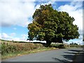
Horse chestnut tree, Middleton
On the north side of Slates Lane, at the end of a field boundary. This side of the lane is also the boundary between West and North Yorkshire.
Image: © Christine Johnstone
Taken: 24 Sep 2014
0.15 miles
6
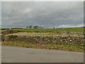
Pinfold off Slates Lane
The former usage is not certain, but seems plausible, see also Image
Image: © Stephen Craven
Taken: 7 Mar 2020
0.16 miles
7
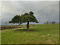
Asymmetric pine tree, Slates Lane
Described as "damaged but surviving" in 2014 Image, it is now actively regrowing.
Image: © Stephen Craven
Taken: 7 Mar 2020
0.16 miles
8
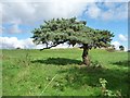
Pine tree, north side, Slates Lane, Middleton
Damaged but surviving.
Image: © Christine Johnstone
Taken: 24 Sep 2014
0.16 miles
9
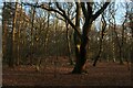
Middleton Woods without the Bluebells
December is not the right time to visit Middleton Woods to witness the famous displays of bluebells.
I note the map records this as Stubham Wood, although locally it is referred to as Middleton Woods with signs reinforcing that fact.
Image: © Chris Heaton
Taken: 20 Dec 2022
0.16 miles
10
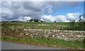
Derelict and disused sheepfold, Middleton
On the north side of Sykes Lane. The near wall is on the boundary between North and West Yorkshire.
Image: © Christine Johnstone
Taken: 24 Sep 2014
0.16 miles