IMAGES TAKEN NEAR TO
ILKLEY, LS29 0BQ
Introduction
This page details the photographs taken nearby to LS29 0BQ by members of the Geograph project.
The Geograph project started in 2005 with the aim of publishing, organising and preserving representative images for every square kilometre of Great Britain, Ireland and the Isle of Man.

There are currently over 7.5m images from over14,400 individuals and you can help contribute to the project by visiting https://www.geograph.org.uk
Image Map (Loading...)


Getting Data...Please wait
Leaflet Map data © OpenStreetMap
Images are licensed for reuse under creativecommons.org/licenses/by-sa/2.0
Notes
- Clicking on the map will re-center to the selected point.
- The higher the marker number, the further away the image location is from the centre of the postcode.
Image Listing (3 Images Found)
Images are licensed for reuse under creativecommons.org/licenses/by-sa/2.0
Image
Details
Distance
1
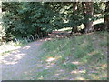
Footpath to Low Austby
Looking north-westward.
Image: © Peter Wood
Taken: 3 Jul 2018
0.11 miles
2
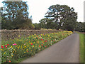
Flower border, High Austby
Someone has gone to great effort to create this spectacular border of wildflowers at the side of Owler Park Road.
Image: © David Spencer
Taken: 29 Sep 2005
0.21 miles
3
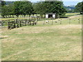
Footpath crossing fields, fences and stiles at Low Austby
Looking westward.
Image: © Peter Wood
Taken: 3 Jul 2018
0.21 miles