IMAGES TAKEN NEAR TO
Low Close, ILKLEY, LS29 0AJ
Introduction
This page details the photographs taken nearby to Low Close, LS29 0AJ by members of the Geograph project.
The Geograph project started in 2005 with the aim of publishing, organising and preserving representative images for every square kilometre of Great Britain, Ireland and the Isle of Man.

There are currently over 7.5m images from over14,400 individuals and you can help contribute to the project by visiting https://www.geograph.org.uk
Image Map
Images are licensed for reuse under creativecommons.org/licenses/by-sa/2.0
Notes
- Clicking on the map will re-center to the selected point.
- The higher the marker number, the further away the image location is from the centre of the postcode.
Image Listing (64 Images Found)
Images are licensed for reuse under creativecommons.org/licenses/by-sa/2.0
Image
Details
Distance

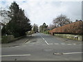
6
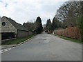
Curly Hill - viewed from Middleton Avenue
Image: © Betty Longbottom
Taken: 23 Mar 2015
0.08 miles
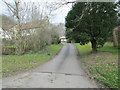
7
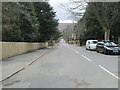
Middleton Avenue - viewed from Curly Hill
Image: © Betty Longbottom
Taken: 23 Mar 2015
0.08 miles
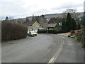
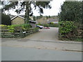
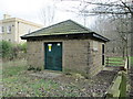
9
Substation on Middleton Avenue, Ilkley
Set in surprisingly spacious grounds for such a facility.
Image: © Stephen Craven
Taken: 7 Mar 2020
0.10 miles
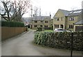
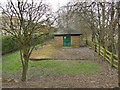
10
Electricity Substation No 4017 - Middleton Avenue
Image: © Betty Longbottom
Taken: 23 Mar 2015
0.10 miles