IMAGES TAKEN NEAR TO
Gilstead Way, ILKLEY, LS29 0AE
Introduction
This page details the photographs taken nearby to Gilstead Way, LS29 0AE by members of the Geograph project.
The Geograph project started in 2005 with the aim of publishing, organising and preserving representative images for every square kilometre of Great Britain, Ireland and the Isle of Man.

There are currently over 7.5m images from over14,400 individuals and you can help contribute to the project by visiting https://www.geograph.org.uk
Image Map
Images are licensed for reuse under creativecommons.org/licenses/by-sa/2.0
Notes
- Clicking on the map will re-center to the selected point.
- The higher the marker number, the further away the image location is from the centre of the postcode.
Image Listing (94 Images Found)
Images are licensed for reuse under creativecommons.org/licenses/by-sa/2.0
Image
Details
Distance


7

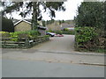
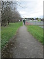
Ilkley Cricket Club Pavilion - viewed from Lido
Image: © Betty Longbottom
Taken: 23 Mar 2015
0.09 miles
9
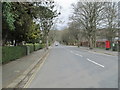
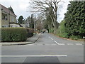
Middleton Avenue - viewed from Denton Road
Image: © Betty Longbottom
Taken: 23 Mar 2015
0.10 miles
10
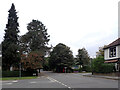
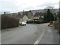
Denton Road and Middleton Avenue, Ilkley
A close-up of the post box can be seen in Image
Image: © habiloid
Taken: 9 Oct 2021
0.10 miles