IMAGES TAKEN NEAR TO
Scargill Buildings, LEEDS, LS27 8SY
Introduction
This page details the photographs taken nearby to Scargill Buildings, LS27 8SY by members of the Geograph project.
The Geograph project started in 2005 with the aim of publishing, organising and preserving representative images for every square kilometre of Great Britain, Ireland and the Isle of Man.

There are currently over 7.5m images from over14,400 individuals and you can help contribute to the project by visiting https://www.geograph.org.uk
Image Map
Images are licensed for reuse under creativecommons.org/licenses/by-sa/2.0
Notes
- Clicking on the map will re-center to the selected point.
- The higher the marker number, the further away the image location is from the centre of the postcode.
Image Listing (55 Images Found)
Images are licensed for reuse under creativecommons.org/licenses/by-sa/2.0
Image
Details
Distance
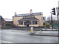
1
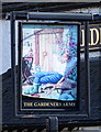
The Gardeners, Morley.
The Gardeners, a Tetleys pub on the junction of Magpie Lane and Middleton Road. Taken from the end of Albert Road.
Image: © Steve Partridge
Taken: 2 Oct 2005
0.01 miles
8
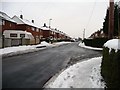
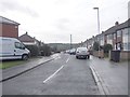
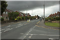
Newlands Drive, Morley
Unlike its side streets and its pavements, this road is clear of snow.
Image: © Christine Johnstone
Taken: 23 Jan 2013
0.06 miles
10
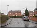
Newlands Crescent - Newlands Drive
Image: © Betty Longbottom
Taken: 17 Mar 2012
0.07 miles