IMAGES TAKEN NEAR TO
Albert Drive, LEEDS, LS27 8SF
Introduction
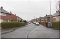
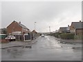
This page details the photographs taken nearby to Albert Drive, LS27 8SF by members of the Geograph project.
The Geograph project started in 2005 with the aim of publishing, organising and preserving representative images for every square kilometre of Great Britain, Ireland and the Isle of Man.

There are currently over 7.5m images from over14,400 individuals and you can help contribute to the project by visiting https://www.geograph.org.uk
Image Map
Images are licensed for reuse under creativecommons.org/licenses/by-sa/2.0
Notes
- Clicking on the map will re-center to the selected point.
- The higher the marker number, the further away the image location is from the centre of the postcode.
Image Listing (44 Images Found)
Images are licensed for reuse under creativecommons.org/licenses/by-sa/2.0
Image
Details
Distance
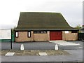
5
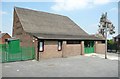
Newlands Methodist Church, Albert Drive, Morley
This serves the housing estates on the eastern side of Morley.
Image: © Humphrey Bolton
Taken: 3 Jun 2010
0.04 miles
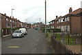
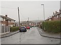
10
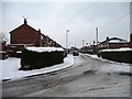
Junction of Rydal and Newlands Crescent, Morley
As the streets loop back on themselves, they have little through traffic and are still full of snow.
Image: © Christine Johnstone
Taken: 23 Jan 2013
0.13 miles