IMAGES TAKEN NEAR TO
Denshaw Drive, LEEDS, LS27 8RS
Introduction
This page details the photographs taken nearby to Denshaw Drive, LS27 8RS by members of the Geograph project.
The Geograph project started in 2005 with the aim of publishing, organising and preserving representative images for every square kilometre of Great Britain, Ireland and the Isle of Man.

There are currently over 7.5m images from over14,400 individuals and you can help contribute to the project by visiting https://www.geograph.org.uk
Image Map (Loading...)


Getting Data...Please wait
Leaflet Map data © OpenStreetMap
Images are licensed for reuse under creativecommons.org/licenses/by-sa/2.0
Notes
- Clicking on the map will re-center to the selected point.
- The higher the marker number, the further away the image location is from the centre of the postcode.
Image Listing (90 Images Found)
Images are licensed for reuse under creativecommons.org/licenses/by-sa/2.0
Image
Details
Distance
6
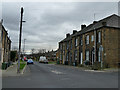
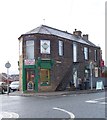
Two periods of housing, Peel Street, Morley
The 1933 OS map shows Peel Street stopping at the few terraced houses beyond this junction with Clough Street. Later housing (probably 1960s) is set much further back from the road, reflecting the growing expectations of post-war homeowners.
Image: © Stephen Craven
Taken: 11 Jan 2020
0.12 miles
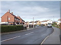
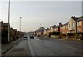
7
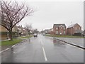
Middleton Road - viewed from Wide Lane
Image: © Betty Longbottom
Taken: 17 Mar 2012
0.12 miles
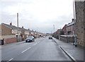
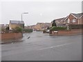
9
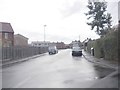
Priority this way
Middleton Road, Morley.
Image: © Steve Fareham
Taken: 14 Jan 2009
0.13 miles