IMAGES TAKEN NEAR TO
Tennyson Terrace, LEEDS, LS27 8QP
Introduction
This page details the photographs taken nearby to Tennyson Terrace, LS27 8QP by members of the Geograph project.
The Geograph project started in 2005 with the aim of publishing, organising and preserving representative images for every square kilometre of Great Britain, Ireland and the Isle of Man.

There are currently over 7.5m images from over14,400 individuals and you can help contribute to the project by visiting https://www.geograph.org.uk
Image Map
Images are licensed for reuse under creativecommons.org/licenses/by-sa/2.0
Notes
- Clicking on the map will re-center to the selected point.
- The higher the marker number, the further away the image location is from the centre of the postcode.
Image Listing (187 Images Found)
Images are licensed for reuse under creativecommons.org/licenses/by-sa/2.0
Image
Details
Distance
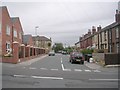
3
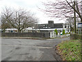
Knowle Manor, Morley
A residential care home for the elderly, operated by Leeds City Council.
Image: © Stephen Craven
Taken: 11 Jan 2020
0.03 miles
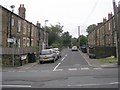
5
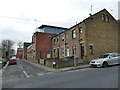
Old and new housing, Tennyson Street, Morley
The sign warning of children crossing is probably because of a day nursery a little higher up Peel Street.
Image: © Stephen Craven
Taken: 11 Jan 2020
0.04 miles
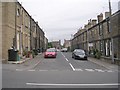
6
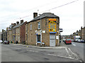
Ishi's (Closed), Peel Street, Morley
This convenience store was still open in 2010 Image but has now closed for good.
Image: © Stephen Craven
Taken: 11 Jan 2020
0.04 miles
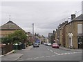
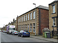
9
City Mills, South Parade, Morley
The original City Mill (woollen) Image was on the opposite side of Peel Street (to the left of this photo) and still exists but reduced in size. This early 20th century building is now a small business centre.
Image: © Stephen Craven
Taken: 11 Jan 2020
0.05 miles
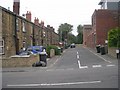
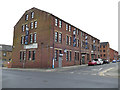
10
Former warehouse, Peel Street, Morley
The 1933 OS map shows this as a warehouse but it is now apartments. The return wing to the south is actually longer than the street frontage.
Image: © Stephen Craven
Taken: 11 Jan 2020
0.05 miles