IMAGES TAKEN NEAR TO
Wide Lane, LEEDS, LS27 8PL
Introduction
This page details the photographs taken nearby to Wide Lane, LS27 8PL by members of the Geograph project.
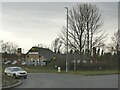
The Geograph project started in 2005 with the aim of publishing, organising and preserving representative images for every square kilometre of Great Britain, Ireland and the Isle of Man.

There are currently over 7.5m images from over14,400 individuals and you can help contribute to the project by visiting https://www.geograph.org.uk
Image Map (Loading...)


Getting Data...Please wait
Leaflet Map data © OpenStreetMap
Images are licensed for reuse under creativecommons.org/licenses/by-sa/2.0
Notes
- Clicking on the map will re-center to the selected point.
- The higher the marker number, the further away the image location is from the centre of the postcode.
Image Listing (19 Images Found)
Images are licensed for reuse under creativecommons.org/licenses/by-sa/2.0
Image
Details
Distance
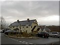
1
McDonald's at Wide Lane End
This used to be a Harvester restaurant when photographed in 2008 Image and is still shown with the 'public house' symbol on the current Explorer map, so McDonald's may only recently have acquired the site.
Image: © Stephen Craven
Taken: 19 Feb 2023
0.00 miles
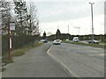
2
Harvester public house
Junction with Wide Lane and the Leeds ring road.
Image: © Steve Fareham
Taken: 11 Mar 2008
0.01 miles
3
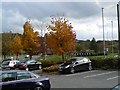
Autumn colours in the car park
At the Harvester restaurant on the A653 near Morley.
Image: © James Allan
Taken: 23 Oct 2009
0.04 miles
4
Wide Lane End bus stop
Wide Lane is the road that goes right at the roundabout, towards Morley.
Image: © Stephen Craven
Taken: 19 Feb 2023
0.05 miles
5
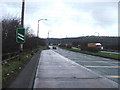
Dewsbury Road, Morley.
Looking N towards the junction (roundabout) with Wide Lane.
Image: © Steve Partridge
Taken: 27 Jan 2006
0.09 miles
6
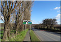
Wide Lane (B6123), Morley
Approaching the A653.
Image: © JThomas
Taken: 27 Feb 2020
0.14 miles
7
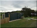
The Red Kite Cafe, Dewsbury Road
Situated in a layby Image, the cafe consists of basic facilities in a shipping container, with a couple of portable toilets outside.
Image: © Stephen Craven
Taken: 19 Feb 2023
0.15 miles
8
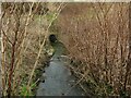
Start of Mill Beck culvert
The 1957 map still shows Mill Farm a short distance to the right of this photo, but none of its buildings remain. The older map also shows the beck continuing its progress between fields north of this point, forming the boundary between Leeds and Morley boroughs, but it is now culverted for a distance of about 650m downstream, the ground level having been raised (possibly by landfill operations?)
Image: © Stephen Craven
Taken: 19 Feb 2023
0.15 miles
9
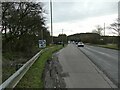
Layby on the A653 Dewsbury Road
There is still a sign indicating an emergency phone point, but like most (if not all) such facilities, it has been removed in the age of the mobile phone.
Image: © Stephen Craven
Taken: 19 Feb 2023
0.15 miles