IMAGES TAKEN NEAR TO
Union Street, LEEDS, LS27 7ZD
Introduction
This page details the photographs taken nearby to Union Street, LS27 7ZD by members of the Geograph project.
The Geograph project started in 2005 with the aim of publishing, organising and preserving representative images for every square kilometre of Great Britain, Ireland and the Isle of Man.

There are currently over 7.5m images from over14,400 individuals and you can help contribute to the project by visiting https://www.geograph.org.uk
Image Map
Images are licensed for reuse under creativecommons.org/licenses/by-sa/2.0
Notes
- Clicking on the map will re-center to the selected point.
- The higher the marker number, the further away the image location is from the centre of the postcode.
Image Listing (136 Images Found)
Images are licensed for reuse under creativecommons.org/licenses/by-sa/2.0
Image
Details
Distance
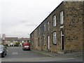
3
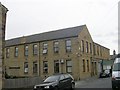
Churwell Independent Co-operative Society Ltd - Fountain Street
Built 1873.
Image: © Betty Longbottom
Taken: 21 Sep 2009
0.02 miles
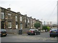
4
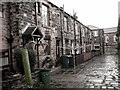
Back Clarendon Terrace, Park St, Churwell
Fleming family at No:18--1891
Image: © Bryan Sykes
Taken: 19 Sep 2006
0.02 miles
5
Cooperative Street - Fountain Street
Image: © Betty Longbottom
Taken: 21 Sep 2009
0.02 miles
6
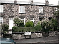
Clarendon Terrace, Park Street, Churwell
Image: © Bryan Sykes
Taken: 18 Sep 2006
0.02 miles
8
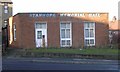
Stanhope Memorial Hall - Elland Road
Image: © Betty Longbottom
Taken: 11 Dec 2007
0.03 miles
10
Churwell War Memorial & Garden - Elland Road
Image: © Betty Longbottom
Taken: 11 Dec 2007
0.03 miles