IMAGES TAKEN NEAR TO
Victoria Street, LEEDS, LS27 7TG
Introduction
This page details the photographs taken nearby to Victoria Street, LS27 7TG by members of the Geograph project.
The Geograph project started in 2005 with the aim of publishing, organising and preserving representative images for every square kilometre of Great Britain, Ireland and the Isle of Man.

There are currently over 7.5m images from over14,400 individuals and you can help contribute to the project by visiting https://www.geograph.org.uk
Image Map
Images are licensed for reuse under creativecommons.org/licenses/by-sa/2.0
Notes
- Clicking on the map will re-center to the selected point.
- The higher the marker number, the further away the image location is from the centre of the postcode.
Image Listing (139 Images Found)
Images are licensed for reuse under creativecommons.org/licenses/by-sa/2.0
Image
Details
Distance
1
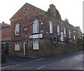
Churwell Community Centre - Victoria Street
Built by the overseers of the poor for the township of Churwell in 1862.
Image: © Betty Longbottom
Taken: 11 Dec 2007
0.01 miles
2
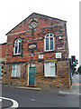
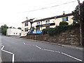
The Old Poor House, Victoria Street, Churwell
An odd building, erected in 1856 Image and grade II listed (list entry 1250731). It appears now to be in residential use.
Image: © Stephen Craven
Taken: 21 Jul 2020
0.02 miles
3
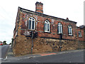
The Old Poor House, Elland Road, Churwell
An odd building, erected in 1856 Image and grade II listed (list entry 1250731). It appears now to be in residential use. This is the side view, see also Image There is a pelican crossing in the foreground.
Image: © Stephen Craven
Taken: 21 Jul 2020
0.02 miles
4
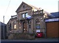
Rainbow, Elland Road, Churwell
Rainbow is the building in a version of Classical style with a big pediment. Was it a chapel? The decoration is rather ornate and secular in character.
Image: © Humphrey Bolton
Taken: 16 Mar 2010
0.02 miles
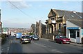
5
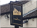
Sign for The Commercial, Elland Road, Churwell
See Image for context.
Image: © Stephen Craven
Taken: 21 Jul 2020
0.03 miles
6
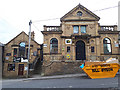
Former Mount Zion chapel, Elland Road, Churwell
A former Primitive Methodist chapel, built c.1861, closure date unknown although it was before the grade II listing (list entry 1313452) was updated in 1986. It is now the home of YB Communications. The listing includes the former caretaker's house to the left, now a tattoo studio called "Ink Religion". What would the minister have thought of that?
Image: © Stephen Craven
Taken: 21 Jul 2020
0.03 miles
7
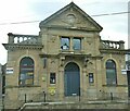
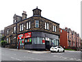
Phoenix House, Churwell
A former Primitive Methodist chapel, built c.1861, grade II listed (list entry 1313452). Since I photographed the building two years earlier Image the 'Rainbow' branding has gone, revealing the earlier name 'Phoenix House' beneath the pediment. It's currently occupied by Northern Telecom. Note the defibrillator on the wall.
Image: © Stephen Craven
Taken: 18 Apr 2022
0.03 miles
9
The Commercial, Elland Road, Churwell
The pub may have been here since the Leeds to Elland turnpike road was built in 1815. The 1908 map shows a smithy adjacent, which would fit with it being a coaching inn. The pub was described in a CAMRA guide to Leeds pubs published in 1993 as 'pleasantly refurbished ... with an upstairs family room'.
Image: © Stephen Craven
Taken: 21 Jul 2020
0.03 miles
10
Estate agents, Elland Road, Churwell
The building now housing "Sell My Own Place" estate agents has a carved stone coat of arms on the top corner. I suspect it may have been a Co-Operative Society store, records indicate the Churwell Co-Operative Society was wound up in 1932 but I have not found an address for it.
Image: © Stephen Craven
Taken: 21 Jul 2020
0.04 miles