IMAGES TAKEN NEAR TO
Elland Road, LEEDS, LS27 7QR
Introduction
This page details the photographs taken nearby to Elland Road, LS27 7QR by members of the Geograph project.
The Geograph project started in 2005 with the aim of publishing, organising and preserving representative images for every square kilometre of Great Britain, Ireland and the Isle of Man.

There are currently over 7.5m images from over14,400 individuals and you can help contribute to the project by visiting https://www.geograph.org.uk
Image Map (Loading...)


Getting Data...Please wait
Leaflet Map data © OpenStreetMap
Images are licensed for reuse under creativecommons.org/licenses/by-sa/2.0
Notes
- Clicking on the map will re-center to the selected point.
- The higher the marker number, the further away the image location is from the centre of the postcode.
Image Listing (142 Images Found)
Images are licensed for reuse under creativecommons.org/licenses/by-sa/2.0
Image
Details
Distance
1
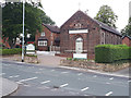
Little Buttons nursery, Elland Road, Churwell
The nursery occupies the former St Brigid's Catholic Church, built in 1929 by architect Charles Edward Fox with adjacent presbytery and closed for worship in 2010 (info from the Twentieth Century Society and parish websites). See Image for when it was still open in 2000.
Image: © Stephen Craven
Taken: 21 Jul 2020
0.02 miles
2
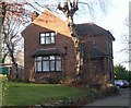
St Brigid's Presbytery - Elland Road
Image: © Betty Longbottom
Taken: 11 Dec 2007
0.03 miles
3
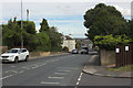
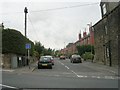
Elland Road
Taken from the junction with Harwill Avenue
Image: © Mark Anderson
Taken: 5 Aug 2016
0.03 miles
6
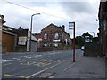
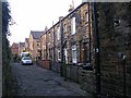
Churwell Town Hall
On Elland Road up Churwell Hill.
Image: © Steve Partridge
Taken: 2 Oct 2005
0.04 miles
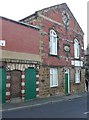
7
Mount Zion Chapel - Elland Road
Built 1861 - currently undergoing conversion.
Image: © Betty Longbottom
Taken: 11 Dec 2007
0.04 miles
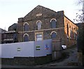
8

Former Mount Zion chapel, Elland Road, Churwell
Now refurbished as commercial premises. The chapel evidently had an attached house, and a Sunday school building at the rear.
Image: © Humphrey Bolton
Taken: 16 Mar 2010
0.04 miles
9
Former poor house
Built in 1865 by the 'overseers of the poor' of Churwell Township.
Image: © Humphrey Bolton
Taken: 16 Mar 2010
0.04 miles
10
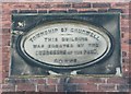
Date stone on the former Churwell poor house
Image: © Humphrey Bolton
Taken: 16 Mar 2010
0.04 miles