IMAGES TAKEN NEAR TO
Daffil Avenue, LEEDS, LS27 7QD
Introduction
This page details the photographs taken nearby to Daffil Avenue, LS27 7QD by members of the Geograph project.
The Geograph project started in 2005 with the aim of publishing, organising and preserving representative images for every square kilometre of Great Britain, Ireland and the Isle of Man.

There are currently over 7.5m images from over14,400 individuals and you can help contribute to the project by visiting https://www.geograph.org.uk
Image Map (Loading...)


Getting Data...Please wait
Leaflet Map data © OpenStreetMap
Images are licensed for reuse under creativecommons.org/licenses/by-sa/2.0
Notes
- Clicking on the map will re-center to the selected point.
- The higher the marker number, the further away the image location is from the centre of the postcode.
Image Listing (133 Images Found)
Images are licensed for reuse under creativecommons.org/licenses/by-sa/2.0
Image
Details
Distance
1
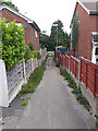
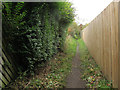
Path into Churwell Park - from Daffil Avenue
Image: © Stephen Craven
Taken: 21 Jul 2020
0.01 miles
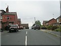
2
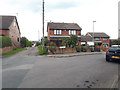
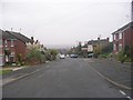
Daffil Avenue, Churwell
The road takes its name from Daffil Farm on whose land the housing estate was built. The farm buildings are no longer extant. The unsurfaced road to the left leads to some older cottages called Daffil Row - presumably farm workers' houses originally.
Image: © Stephen Craven
Taken: 21 Jul 2020
0.02 miles
5
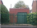
Electricity Substation No 2725 - Crossland Road
Image: © Betty Longbottom
Taken: 7 Nov 2011
0.04 miles
7
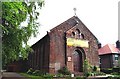
Churwell, St Brigid's R.C. Church
This Church is situated on the western side of the A643. It occupies a central position on the western edge of the O/S grid which it occupies.
Image: © Bill Henderson
Taken: Unknown
0.05 miles
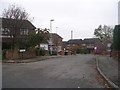
8
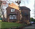
St Brigid's Presbytery - Elland Road
Image: © Betty Longbottom
Taken: 11 Dec 2007
0.06 miles
9
Daffil Grove - looking towards Hepworth Avenue
Image: © Betty Longbottom
Taken: 7 Nov 2011
0.06 miles
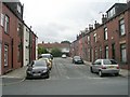
10
Smools Lane, Churwell
A historic right of way shown on 19th century maps, now a footpath through a housing estate Image
Image: © Stephen Craven
Taken: 18 Oct 2015
0.06 miles