IMAGES TAKEN NEAR TO
LS27 7NW
Introduction
This page details the photographs taken nearby to LS27 7NW by members of the Geograph project.
The Geograph project started in 2005 with the aim of publishing, organising and preserving representative images for every square kilometre of Great Britain, Ireland and the Isle of Man.

There are currently over 7.5m images from over14,400 individuals and you can help contribute to the project by visiting https://www.geograph.org.uk
Image Map
Images are licensed for reuse under creativecommons.org/licenses/by-sa/2.0
Notes
- Clicking on the map will re-center to the selected point.
- The higher the marker number, the further away the image location is from the centre of the postcode.
Image Listing (41 Images Found)
Images are licensed for reuse under creativecommons.org/licenses/by-sa/2.0
Image
Details
Distance
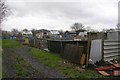
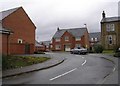
2
Treefield Industrial Estate - Gelderd Road
Image: © Betty Longbottom
Taken: 3 Sep 2011
0.11 miles
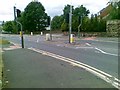

5
Windmill Lane, Gildersome
The windmill itself was in the opposite direction and is long vanished (the site now being part of an industrial estate).
Image: © Stephen Craven
Taken: 18 Apr 2022
0.13 miles
7
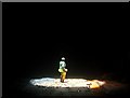
Gildersome railway tunnel air shaft
View from directly under the open air shaft in Gildersome tunnel. More 2008 pictures inside the tunnel can be seen here http://blog.myspace.com/index.cfm?fuseaction=blog.view&friendID=265602590&blogID=326762127
Image: © philld
Taken: 3 Nov 2007
0.15 miles
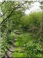
8
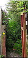
Footpath and Nettles: Gildersome
Another narrow gateway and a rather overgrown footpath. The path links A650 with A62.Try it maybe but wear long trousers!
Image: © John Readman
Taken: 23 May 2007
0.16 miles
9
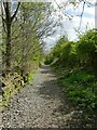
Stone Pits Lane, off Gelderd Road, Gildersome
Part of a public footpath from Gildersome to Bruntcliffe (now cut off by the M621 motorway).
Image: © Stephen Craven
Taken: 18 Apr 2022
0.16 miles
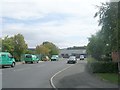
10
Gelderd Road - viewed from College Road
Image: © Betty Longbottom
Taken: 22 Jun 2010
0.16 miles