IMAGES TAKEN NEAR TO
Gelderd Road, LEEDS, LS27 7LS
Introduction
This page details the photographs taken nearby to Gelderd Road, LS27 7LS by members of the Geograph project.
The Geograph project started in 2005 with the aim of publishing, organising and preserving representative images for every square kilometre of Great Britain, Ireland and the Isle of Man.

There are currently over 7.5m images from over14,400 individuals and you can help contribute to the project by visiting https://www.geograph.org.uk
Image Map (Loading...)


Getting Data...Please wait
Leaflet Map data © OpenStreetMap
Images are licensed for reuse under creativecommons.org/licenses/by-sa/2.0
Notes
- Clicking on the map will re-center to the selected point.
- The higher the marker number, the further away the image location is from the centre of the postcode.
Image Listing (31 Images Found)
Images are licensed for reuse under creativecommons.org/licenses/by-sa/2.0
Image
Details
Distance
1
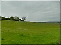
Field below Gilead House Farm
The field contained some apparently disused horse jumps.
Image: © Stephen Craven
Taken: 9 May 2021
0.09 miles
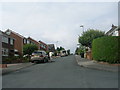
3
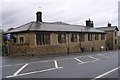
Old School - Gelderd Road
Now converted into private housing.
Image: © Betty Longbottom
Taken: 8 Jan 2008
0.12 miles
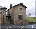
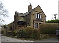
5
Former school, Gelderd Road, Gildersome
A former Board school dating from 1875, now a private house.
Image: © Stephen Craven
Taken: 9 May 2021
0.13 miles
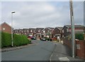
6
Highfield Close - looking towards Branch End
Image: © Betty Longbottom
Taken: 1 Aug 2011
0.13 miles
7

Woodlands Lodge, Gelderd Road, Gildersome
Woodlands itself is a country house dating from c.1880 by W Hanstock, now a wedding venue Image I presume the lodge is by the same architect and around the same date.
Image: © Stephen Craven
Taken: 9 May 2021
0.15 miles
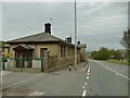
9

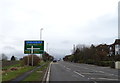
The A62, Gelderd Road, Gildersome
The building is shown as a school on a mid-20C six-inch map.
Image: © Humphrey Bolton
Taken: 3 Jun 2010
0.16 miles