IMAGES TAKEN NEAR TO
Reedsdale Avenue, LEEDS, LS27 7JE
Introduction
This page details the photographs taken nearby to Reedsdale Avenue, LS27 7JE by members of the Geograph project.
The Geograph project started in 2005 with the aim of publishing, organising and preserving representative images for every square kilometre of Great Britain, Ireland and the Isle of Man.

There are currently over 7.5m images from over14,400 individuals and you can help contribute to the project by visiting https://www.geograph.org.uk
Image Map (Loading...)


Getting Data...Please wait
Leaflet Map data © OpenStreetMap
Images are licensed for reuse under creativecommons.org/licenses/by-sa/2.0
Notes
- Clicking on the map will re-center to the selected point.
- The higher the marker number, the further away the image location is from the centre of the postcode.
Image Listing (145 Images Found)
Images are licensed for reuse under creativecommons.org/licenses/by-sa/2.0
Image
Details
Distance
1
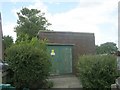
Electricity Substation No 2864 - Reedsdale Gardens
Image: © Betty Longbottom
Taken: 11 Jun 2011
0.01 miles
2
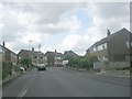
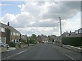
Reedsdale Avenue - Reedsdale Gardens
Image: © Betty Longbottom
Taken: 11 Jun 2011
0.03 miles
3
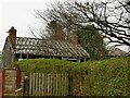
Derelict building at Lane Top, Gildersome
Only the timber frame and brick chimneys remain. The 1908 map shows a small colliery nearby so it's possible this was related to it, but it now appears to be within a private garden.
Image: © Stephen Craven
Taken: 21 Mar 2021
0.05 miles
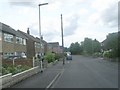
4
Reedsdale Gardens - looking towards Street Lane
Image: © Betty Longbottom
Taken: 11 Jun 2011
0.05 miles
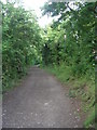
6
Leeds Country Way, Gildersome
Following the route from Cockersdale, it finally leads through this snicket to emerge in Gildersome beside the post office.
Image: © Chris Heaton
Taken: 27 Jan 2009
0.06 miles
7
Small park off Woodhead Lane, Gildersome
To the right is an extensive children's play area but it was well used at the time of the photo so I have cropped any children out of the picture.
Image: © Stephen Craven
Taken: 21 Mar 2021
0.07 miles
8
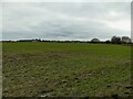
Waterlogged field off Woodhead Lane, Gildersome
There seemed to be a crop growing. In the distance is the chimney of the former brickworks adjacent to the M62.
Image: © Stephen Craven
Taken: 21 Mar 2021
0.08 miles
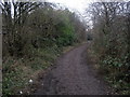
9
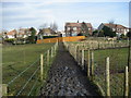
Leeds Country Way skirting Gildersome
The route follows a tortuous course through and around Gildersome. As can be seen it has become a sloppy mess and almost unwalkable in parts. It used to be a pleasing long distance footpath, but has obviously been neglected and allowed to fall into the state as seen in the photograph. The signs and waymarks seem to have disappeared as well.
Image: © Chris Heaton
Taken: 27 Jan 2009
0.08 miles