IMAGES TAKEN NEAR TO
May Avenue, LEEDS, LS27 7GJ
Introduction
This page details the photographs taken nearby to May Avenue, LS27 7GJ by members of the Geograph project.
The Geograph project started in 2005 with the aim of publishing, organising and preserving representative images for every square kilometre of Great Britain, Ireland and the Isle of Man.

There are currently over 7.5m images from over14,400 individuals and you can help contribute to the project by visiting https://www.geograph.org.uk
Image Map (Loading...)


Getting Data...Please wait
Leaflet Map data © OpenStreetMap
Images are licensed for reuse under creativecommons.org/licenses/by-sa/2.0
Notes
- Clicking on the map will re-center to the selected point.
- The higher the marker number, the further away the image location is from the centre of the postcode.
Image Listing (71 Images Found)
Images are licensed for reuse under creativecommons.org/licenses/by-sa/2.0
Image
Details
Distance
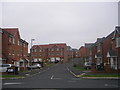
3
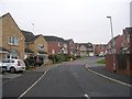
Westwood Park, Churwell
A new development, an extension of the existing New Village Way estate.
Image: © Stephen Craven
Taken: 21 Jul 2020
0.06 miles
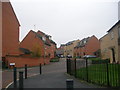
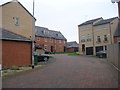
9
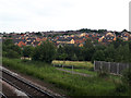
View from Cottingley station towards Churwell
The New Village Way estate is in the middle distance.
Image: © Stephen Craven
Taken: 21 Jul 2020
0.09 miles
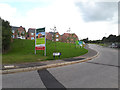
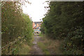
10
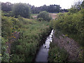
Farnley Wood Beck, Churwell
Viewed from Digpal Road. The beck was once the boundary between Morley and Leeds boroughs, but Morley is now part of Leeds.
Image: © Stephen Craven
Taken: 21 Jul 2020
0.09 miles