IMAGES TAKEN NEAR TO
Harthill Lane, LEEDS, LS27 7BP
Introduction
This page details the photographs taken nearby to Harthill Lane, LS27 7BP by members of the Geograph project.
The Geograph project started in 2005 with the aim of publishing, organising and preserving representative images for every square kilometre of Great Britain, Ireland and the Isle of Man.

There are currently over 7.5m images from over14,400 individuals and you can help contribute to the project by visiting https://www.geograph.org.uk
Image Map (Loading...)


Getting Data...Please wait
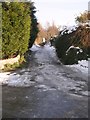
Leaflet Map data © OpenStreetMap
Images are licensed for reuse under creativecommons.org/licenses/by-sa/2.0
Notes
- Clicking on the map will re-center to the selected point.
- The higher the marker number, the further away the image location is from the centre of the postcode.
Image Listing (159 Images Found)
Images are licensed for reuse under creativecommons.org/licenses/by-sa/2.0
Image
Details
Distance
1
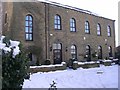
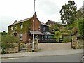
Chapel House - Harthill Lane
Built 1893 - now converted for residential use.
Image: © Betty Longbottom
Taken: 7 Feb 2009
0.00 miles
2
Chapel House, Harthill Lane, Gildersome
The building bears the date 1893. Comparing old maps, this was in fact the Sunday school for the Mount Zion Free Methodist Chapel, which was to the right in this view but has since been demolished.
Image: © Stephen Craven
Taken: 21 Mar 2021
0.00 miles
3
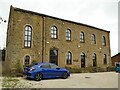
Chapel House, Harthill Lane, Gildersome - east end
The clearest view of this end of the former Sunday school building Image is from further up the lane.
Image: © Stephen Craven
Taken: 21 Mar 2021
0.00 miles
7
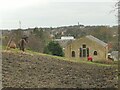
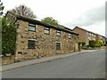
Croft House, Harthill Rise, Gildersome
According to the gildersome.net local website, Croft House was built sometime between 1915 and 1930, replacing an older farmhouse nearby. An adjacent building survives from the original farm Image
Image: © Stephen Craven
Taken: 9 May 2021
0.03 miles
8
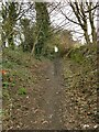
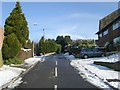
Harthill Lane, Gildersome
Beyond Chapel House Image the lane becomes a public footpath, which looks as if would be quite muddy in winter (this was after a few weeks of dry weather).
Image: © Stephen Craven
Taken: 21 Mar 2021
0.03 miles
9
Old farm building, Harthill Rise, Gildersome
This is the last surviving building of the 19th century (or earlier) Croft Farm, now in residential use, but the blocked doorway at the far end of the ground floor retains a timber lintel. According to the gildersome.net local website, Croft Farm was a dairy farm, and glebe property for the Vicar of Tong until 1920.
Image: © Stephen Craven
Taken: 9 May 2021
0.03 miles