IMAGES TAKEN NEAR TO
Gildersome Lane, LEEDS, LS27 7BB
Introduction
This page details the photographs taken nearby to Gildersome Lane, LS27 7BB by members of the Geograph project.
The Geograph project started in 2005 with the aim of publishing, organising and preserving representative images for every square kilometre of Great Britain, Ireland and the Isle of Man.

There are currently over 7.5m images from over14,400 individuals and you can help contribute to the project by visiting https://www.geograph.org.uk
Image Map (Loading...)


Getting Data...Please wait
Leaflet Map data © OpenStreetMap
Images are licensed for reuse under creativecommons.org/licenses/by-sa/2.0
Notes
- Clicking on the map will re-center to the selected point.
- The higher the marker number, the further away the image location is from the centre of the postcode.
Image Listing (62 Images Found)
Images are licensed for reuse under creativecommons.org/licenses/by-sa/2.0
Image
Details
Distance
2
Boundary stone, Gildersome Lane
The stone is by the wheelie bin; see Image for a close view.
Image: © Humphrey Bolton
Taken: 1 Nov 2012
0.01 miles
3
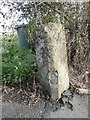
Boundary stone, Gildersome Lane
Farnley to the left and Gildersome to the right. The inscriptions have gone.
Image: © Humphrey Bolton
Taken: 1 Nov 2012
0.01 miles
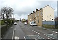
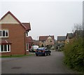
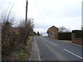
5

Moorhead Villas
Houses on Gildersome Lane (B6126).
Image: © JThomas
Taken: 14 Feb 2020
0.03 miles
6
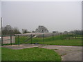
Covered Reservoir - Gildersome Lane
Image: © Betty Longbottom
Taken: 29 Mar 2011
0.04 miles
7
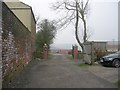
Track by Springfield Villas - Gildersome Lane
Image: © Betty Longbottom
Taken: 29 Mar 2011
0.05 miles
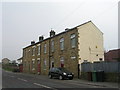
9
Gildersome Lane near Mooside Villas
Looking north-eastward.
Image: © Peter Wood
Taken: 28 Jul 2017
0.06 miles
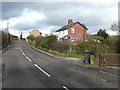
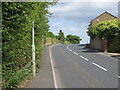
10
Gildersome Lane (B6126)
Uphill towards Upper Moor Side.
Image: © JThomas
Taken: 14 Feb 2020
0.06 miles