IMAGES TAKEN NEAR TO
Church Street, LEEDS, LS27 7AE
Introduction
This page details the photographs taken nearby to Church Street, LS27 7AE by members of the Geograph project.
The Geograph project started in 2005 with the aim of publishing, organising and preserving representative images for every square kilometre of Great Britain, Ireland and the Isle of Man.

There are currently over 7.5m images from over14,400 individuals and you can help contribute to the project by visiting https://www.geograph.org.uk
Image Map (Loading...)


Getting Data...Please wait
Leaflet Map data © OpenStreetMap
Images are licensed for reuse under creativecommons.org/licenses/by-sa/2.0
Notes
- Clicking on the map will re-center to the selected point.
- The higher the marker number, the further away the image location is from the centre of the postcode.
Image Listing (201 Images Found)
Images are licensed for reuse under creativecommons.org/licenses/by-sa/2.0
Image
Details
Distance
1
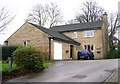
St Peter's Vicarage - Church Street, Gildersome
Image: © Betty Longbottom
Taken: 4 Jan 2008
0.02 miles
2
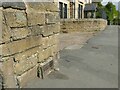
Cable marker, Church Street, Gildersome
A part-buried metal plate reading 'Yorkshire Electric Cables'.
Image: © Stephen Craven
Taken: 18 Apr 2022
0.02 miles
3
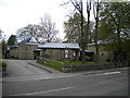
St Peter's church, Gildersome
Consecrated in 1992, this is the third church on this site: the building it replaced survived long enough for my parents to be married in it in 1980, but was demolished later that decade due to structural damage (which resulted from mining related subsidence, if memory serves). The second church had a life of barely a century, the first having been damaged beyond repair by fire. The stone gate posts (extreme right) are presumably contemporary with either the first or second church.
Image: © Richard Vince
Taken: 18 Apr 2017
0.02 miles
4
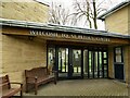
Entrance to St Peter's church, Gildersome
The original church on the site, a chapel of ease to the parish of Batley, was erected in 1774. Following a fire in 1873 it was replaced 1876 by a gothic revival church by Adams and Kelley, consecrated in 1887. The Victorian building suffered serious subsidence problems in the 1970s (perhaps not surprisingly, as there was a coal pit nearby) and closed in 1981. This latest building was, as the foundation stone here shows, erected in 1989.
Image: © Stephen Craven
Taken: 21 Mar 2021
0.02 miles
5
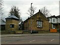
St Peter's church, and hall, Gildersome
The 'hall' part of the 1989 church building Image is on the left and is linked to the older Sunday school building dating from 1837.
Image: © Stephen Craven
Taken: 21 Mar 2021
0.03 miles
6

St Peter's church hall, Gildersome - Brudenell crest
According to a local history website, this was the Sunday school building Image dating from 1837, and the stone crest facing the main road is that of the Brudenell family who gave the land, with the motto "En Grace Affie" translating as "Trust in Grace".
Image: © Stephen Craven
Taken: 21 Mar 2021
0.03 miles
7
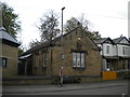
St Peter's church hall, Gildersome
For several uncomfortable years between the demolition of the second St Peter's church and the consecration of the third, this small building was used for church services. The western end of the third church is visible on the left.
Image: © Richard Vince
Taken: 18 Apr 2017
0.03 miles
9
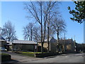
Driveway to Springfield House, Gildersome
This is flanked by tall trees and at first I thought it was an old lane.
Image: © Humphrey Bolton
Taken: 29 Mar 2024
0.03 miles
10

Gildersome cemetery - cremation area
This was originally the churchyard of St Peter's church, from c.1796. The churchyard was closed for burials by Order in Council on 30 June 1865 but interments of cremated remains continue, and it is maintained by Leeds City Council. The building in the background is the current St Peter's church, dating from 1989.
Image: © Stephen Craven
Taken: 21 Mar 2021
0.04 miles