IMAGES TAKEN NEAR TO
Mill Street, LEEDS, LS27 0WJ
Introduction
This page details the photographs taken nearby to Mill Street, LS27 0WJ by members of the Geograph project.
The Geograph project started in 2005 with the aim of publishing, organising and preserving representative images for every square kilometre of Great Britain, Ireland and the Isle of Man.

There are currently over 7.5m images from over14,400 individuals and you can help contribute to the project by visiting https://www.geograph.org.uk
Image Map (Loading...)


Getting Data...Please wait
Leaflet Map data © OpenStreetMap
Images are licensed for reuse under creativecommons.org/licenses/by-sa/2.0
Notes
- Clicking on the map will re-center to the selected point.
- The higher the marker number, the further away the image location is from the centre of the postcode.
Image Listing (181 Images Found)
Images are licensed for reuse under creativecommons.org/licenses/by-sa/2.0
Image
Details
Distance
2
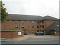
Chartists Court - Great Northern Street
This is an Anchor Housing Complex.
Image: © Betty Longbottom
Taken: 15 Sep 2009
0.05 miles
3
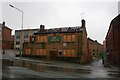
The Albion, Morley
One of Tetleys houses that arguably served the best pint in Morley at one point. The pub sign, now removed, depicted a Roman Centurion and was painted by a local who uses people he knows as models. The Centurion outside the Albion was a former work colleague of mine and the sign outside the Babes in the Wood pub at nearby Woodkirk depicts his children (now grown up though).
Image: © Steve Partridge
Taken: 19 Aug 2007
0.06 miles
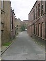
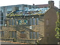
6
Mill Street, Morley
Viewed from Bridge Street, Mill Street is off the beaten track nowadays. The eponymous mill was in front of the white building in the photos, and made 'rags and mungo' (i.e. recycled cloth) but is no longer extant.
Image: © Stephen Craven
Taken: 11 Jan 2020
0.07 miles
7

High Street - viewed from Bridge Street
Image: © Betty Longbottom
Taken: 15 Sep 2009
0.07 miles
8
High Street - viewed from Bridge Street
Image: © Betty Longbottom
Taken: 15 Sep 2009
0.08 miles
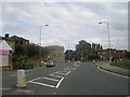
9
Morley (Top) railway station (site), Yorkshire
Opened in 1857 by the Great Northern Railway on the line from Wakefield to Halifax, this station closed in 1969.
View south east towards Tingley and Wakefield. The line ran parallel to, and just behind the wall, and would have cut across the near corner of the building before running onto a viaduct, one abutment of which can still be seen on High Street. The new road in the foreground cuts across the former goods yard. The Stationmaster's house still survives, just behind the camera position.
Image: © Nigel Thompson
Taken: 1 Dec 2013
0.08 miles
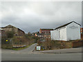
10
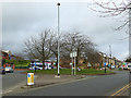
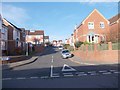
Low Town End roundabout, Morley
At the junction of High Street, Bridge Street (foreground), Mill Street, King Street and the modern Chartists Way (inner ring road).
Image: © Stephen Craven
Taken: 11 Jan 2020
0.08 miles