IMAGES TAKEN NEAR TO
Worrall Street, LEEDS, LS27 0PJ
Introduction
This page details the photographs taken nearby to Worrall Street, LS27 0PJ by members of the Geograph project.
The Geograph project started in 2005 with the aim of publishing, organising and preserving representative images for every square kilometre of Great Britain, Ireland and the Isle of Man.

There are currently over 7.5m images from over14,400 individuals and you can help contribute to the project by visiting https://www.geograph.org.uk
Image Map
Images are licensed for reuse under creativecommons.org/licenses/by-sa/2.0
Notes
- Clicking on the map will re-center to the selected point.
- The higher the marker number, the further away the image location is from the centre of the postcode.
Image Listing (115 Images Found)
Images are licensed for reuse under creativecommons.org/licenses/by-sa/2.0
Image
Details
Distance
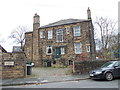
3
Coach House - viewed from New Park Street
Built 1894
Image: © Betty Longbottom
Taken: 28 Nov 2011
0.05 miles
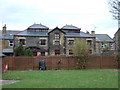
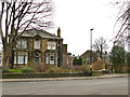
4
Fairfield - viewed from East Park Street
Image: © Betty Longbottom
Taken: 28 Nov 2011
0.05 miles
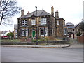
6
Fairfield, St Andrew's Avenue
One of several late Victorian villas in this area that was developed in the 1890s. See also Image for a side view.
Image: © Stephen Craven
Taken: 11 Jan 2020
0.06 miles
7
Fairfield - viewed from New Park Street
Image: © Betty Longbottom
Taken: 28 Nov 2011
0.06 miles
8
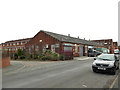
Robrook Printers, Queens Road, Morley
A little bit of industry in an otherwise residential area of town.
Image: © Stephen Craven
Taken: 11 Jan 2020
0.07 miles
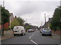
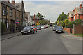
10
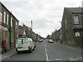
East Park Street - Fountain Street
Image: © Betty Longbottom
Taken: 15 Sep 2009
0.07 miles