IMAGES TAKEN NEAR TO
Marshall Crescent, LEEDS, LS27 0HB
Introduction
This page details the photographs taken nearby to Marshall Crescent, LS27 0HB by members of the Geograph project.
The Geograph project started in 2005 with the aim of publishing, organising and preserving representative images for every square kilometre of Great Britain, Ireland and the Isle of Man.

There are currently over 7.5m images from over14,400 individuals and you can help contribute to the project by visiting https://www.geograph.org.uk
Image Map (Loading...)


Getting Data...Please wait
Leaflet Map data © OpenStreetMap
Images are licensed for reuse under creativecommons.org/licenses/by-sa/2.0
Notes
- Clicking on the map will re-center to the selected point.
- The higher the marker number, the further away the image location is from the centre of the postcode.
Image Listing (89 Images Found)
Images are licensed for reuse under creativecommons.org/licenses/by-sa/2.0
Image
Details
Distance
1
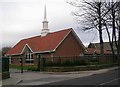
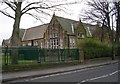
Church of Jesus Christ of Latter Day Saints - Bridge Street
Image: © Betty Longbottom
Taken: 26 Jan 2008
0.01 miles
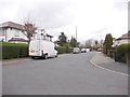
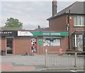
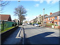
3
Birch Street - looking towards Bridge Street
Image: © Betty Longbottom
Taken: 3 Apr 2012
0.03 miles
4
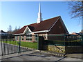
The Church of Jesus Christ of Latter Day Saints, Morley
On Bridge Street (B6127).
Image: © JThomas
Taken: 27 Feb 2020
0.06 miles
7
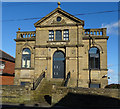
Former Primitive Methodist Chapel on Bridge Street (B6127), Morley
Now converted to flats.
Image: © JThomas
Taken: 27 Feb 2020
0.08 miles
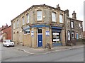
8
Former Post Office - Britannia Road
Image: © Betty Longbottom
Taken: 15 Sep 2009
0.08 miles
10
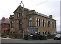
The Chapel - Bridge Street
Primitive Methodist Chapel now converted into flats.
Image: © Betty Longbottom
Taken: 26 Jan 2008
0.08 miles