IMAGES TAKEN NEAR TO
Perry Square, LEEDS, LS27 0FY
Introduction
This page details the photographs taken nearby to Perry Square, LS27 0FY by members of the Geograph project.
The Geograph project started in 2005 with the aim of publishing, organising and preserving representative images for every square kilometre of Great Britain, Ireland and the Isle of Man.

There are currently over 7.5m images from over14,400 individuals and you can help contribute to the project by visiting https://www.geograph.org.uk
Image Map (Loading...)


Getting Data...Please wait
Leaflet Map data © OpenStreetMap
Images are licensed for reuse under creativecommons.org/licenses/by-sa/2.0
Notes
- Clicking on the map will re-center to the selected point.
- The higher the marker number, the further away the image location is from the centre of the postcode.
Image Listing (87 Images Found)
Images are licensed for reuse under creativecommons.org/licenses/by-sa/2.0
Image
Details
Distance
1
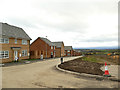
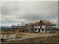
Perry Way estate, Morley (4)
Perry Avenue, with first phase housing to the left; the second phase is now under construction to the right.
Image: © Stephen Craven
Taken: 11 Jan 2020
0.02 miles
2
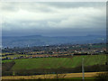
Perry Way estate, Morley (1)
The spine road of a new estate, built on the site of the former Street Farm. It is at virtually the highest point of the town, and offers surprising views to the south and west - looking here across the lower Calder Valley towards Emley Moor transmitter.
Image: © Stephen Craven
Taken: 11 Jan 2020
0.03 miles
3
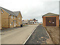
Perry Way estate, Morley (2)
Looking from the first phase of this new estate towards the second phase now under construction. Note the electricity substation included as part of the infrastructure.
Image: © Stephen Craven
Taken: 11 Jan 2020
0.04 miles
4
Perry Way estate, Morley - view to Deer Hill
This new housing estate built on the site of the former Street Farm is at virtually the highest point of the town, and offers surprising views to the south and west - looking here towards Deer Hill and Pule Hill above Marsden.
Image: © Stephen Craven
Taken: 11 Jan 2020
0.04 miles
5
Perry Way estate, Morley - view to Castle Hill
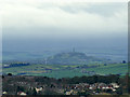
This new housing estate built on the site of the former Street Farm is at virtually the highest point of the town, and offers surprising views to the south and west - looking here towards Castle Hill above Huddersfield.
Image: © Stephen Craven
Taken: 11 Jan 2020
0.04 miles
6
Perry Way estate, Morley (3)
The second phase now under construction.
Image: © Stephen Craven
Taken: 11 Jan 2020
0.04 miles
7
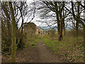
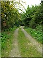
Footpath off Bruntcliffe Road, Morley
The path now runs through the new Perry Way housing estate.
Image: © Stephen Craven
Taken: 11 Jan 2020
0.06 miles
8
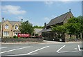
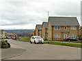
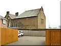
St Andrew's Church, Bruntcliffe Road, Morley
The former vicarage is now a hotel.
Image: © Humphrey Bolton
Taken: 3 Jun 2010
0.08 miles
10
Rear of Thornfield House, Bruntcliffe Road, Morley
The 19th century house, the home of William Jackson, became a Masonic lodge from 1920 (the gabled rear section may be a later extension added by the Freemasons) but is now run as a venue offering weddings and other functions.
Image: © Stephen Craven
Taken: 11 Jan 2020
0.10 miles