IMAGES TAKEN NEAR TO
McLaren Place, LEEDS, LS27 0FS
Introduction
This page details the photographs taken nearby to McLaren Place, LS27 0FS by members of the Geograph project.
The Geograph project started in 2005 with the aim of publishing, organising and preserving representative images for every square kilometre of Great Britain, Ireland and the Isle of Man.

There are currently over 7.5m images from over14,400 individuals and you can help contribute to the project by visiting https://www.geograph.org.uk
Image Map (94 Images)


Getting Data...Please wait
Leaflet Map data © OpenStreetMap
Images are licensed for reuse under creativecommons.org/licenses/by-sa/2.0
Notes
- Clicking on the map will re-center to the selected point.
- The higher the marker number, the further away the image location is from the centre of the postcode.
Image Listing (94 Images Found)
Images are licensed for reuse under creativecommons.org/licenses/by-sa/2.0
Image
Details
Distance

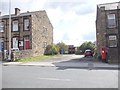
2
Howley Park Close - Scotchman Lane
Image: © Betty Longbottom
Taken: 16 Apr 2012
0.08 miles
4
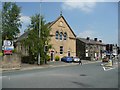
Former chapel, Britannia Road, Morley
Apparently now converted to homes.
Image: © Humphrey Bolton
Taken: 3 Jun 2010
0.10 miles
5
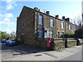
Houses on Scotchman Lane, Morley
Showing position of Postbox No. LS27 437.
See Image] for postbox.
Image: © JThomas
Taken: 27 Feb 2020
0.10 miles
7
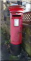
Elizabeth II postbox on Scotchman Lane, Morley
Postbox No. LS27 437.
See Image] for context.
Image: © JThomas
Taken: 27 Feb 2020
0.11 miles
8
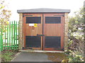
Electricity Substation No 8360 - Nelson Street
Image: © Betty Longbottom
Taken: 16 Apr 2012
0.12 miles