IMAGES TAKEN NEAR TO
Britannia Road, LEEDS, LS27 0AU
Introduction
This page details the photographs taken nearby to Britannia Road, LS27 0AU by members of the Geograph project.
The Geograph project started in 2005 with the aim of publishing, organising and preserving representative images for every square kilometre of Great Britain, Ireland and the Isle of Man.

There are currently over 7.5m images from over14,400 individuals and you can help contribute to the project by visiting https://www.geograph.org.uk
Image Map (Loading...)


Getting Data...Please wait
Leaflet Map data © OpenStreetMap
Images are licensed for reuse under creativecommons.org/licenses/by-sa/2.0
Notes
- Clicking on the map will re-center to the selected point.
- The higher the marker number, the further away the image location is from the centre of the postcode.
Image Listing (98 Images Found)
Images are licensed for reuse under creativecommons.org/licenses/by-sa/2.0
Image
Details
Distance
6
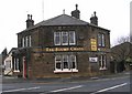
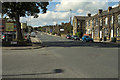
Mermaid fish restaurant, Britannia Road, Morley
Image: © Stephen Craven
Taken: 11 Jan 2020
0.06 miles
7
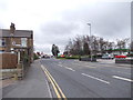
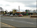
Mermaid Fish Restaurant - Britannia Road
Image: © Betty Longbottom
Taken: 26 Jan 2008
0.07 miles
8
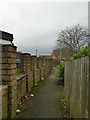
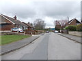
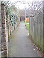
Path from High Street to Alden Avenue, Morley
Image: © Stephen Craven
Taken: 11 Jan 2020
0.07 miles
10
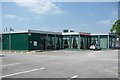
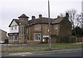
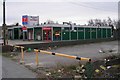
The Mermaid Fish Restaurant, Britannia Road, Morley
The building looks to be prefabricated. If you are thinking of eating here, read the reviews on Yahoo Local first!
Image: © Humphrey Bolton
Taken: 3 Jun 2010
0.08 miles