IMAGES TAKEN NEAR TO
Methley Park, LEEDS, LS26 9DU
Introduction
This page details the photographs taken nearby to Methley Park, LS26 9DU by members of the Geograph project.
The Geograph project started in 2005 with the aim of publishing, organising and preserving representative images for every square kilometre of Great Britain, Ireland and the Isle of Man.

There are currently over 7.5m images from over14,400 individuals and you can help contribute to the project by visiting https://www.geograph.org.uk
Image Map
Images are licensed for reuse under creativecommons.org/licenses/by-sa/2.0
Notes
- Clicking on the map will re-center to the selected point.
- The higher the marker number, the further away the image location is from the centre of the postcode.
Image Listing (20 Images Found)
Images are licensed for reuse under creativecommons.org/licenses/by-sa/2.0
Image
Details
Distance
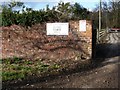
3
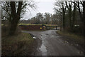
Entrance to Home Farm, Hungate Lane
A Christmas Tree farm.
Image: © Mark Anderson
Taken: 11 Jan 2018
0.08 miles
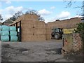
4
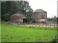
Park Farm
Does a good trade in Christmas trees but not at this time of the year despite the sign.
Image: © Jonathan Thacker
Taken: 28 May 2014
0.08 miles
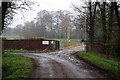
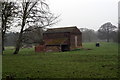
7
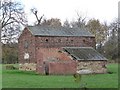
Farm building, off Hungate Lane
Image: © Christine Johnstone
Taken: 20 Nov 2009
0.10 miles