IMAGES TAKEN NEAR TO
Oakdene, LEEDS, LS26 8RB
Introduction
This page details the photographs taken nearby to Oakdene, LS26 8RB by members of the Geograph project.
The Geograph project started in 2005 with the aim of publishing, organising and preserving representative images for every square kilometre of Great Britain, Ireland and the Isle of Man.

There are currently over 7.5m images from over14,400 individuals and you can help contribute to the project by visiting https://www.geograph.org.uk
Image Map (Loading...)


Getting Data...Please wait
Leaflet Map data © OpenStreetMap
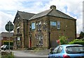
Images are licensed for reuse under creativecommons.org/licenses/by-sa/2.0
Notes
- Clicking on the map will re-center to the selected point.
- The higher the marker number, the further away the image location is from the centre of the postcode.
Image Listing (148 Images Found)
Images are licensed for reuse under creativecommons.org/licenses/by-sa/2.0
Image
Details
Distance
2
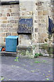
Benchmark on buttress on All Saints Church
Ordnance Survey cut mark benchmark described on the Bench Mark Database at http://www.bench-marks.org.uk/bm48790
Image: © Roger Templeman
Taken: 30 May 2013
0.04 miles
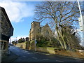
3
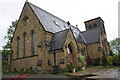
All Saints Church - now a private residence
There is an OS benchmark Image on the buttress right of the green tank. Previously the church had a spire which was an OS intersected station trig point, http://www.trigpointinguk.com/trigs/trig-details.php?t=11663
Image: © Roger Templeman
Taken: 30 May 2013
0.04 miles
5
Jolly Giraffes Day Nursery - Station Lane, Woodlesford
Image: © Betty Longbottom
Taken: 11 Jun 2008
0.04 miles
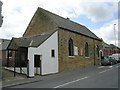
6
Grade II listed converted church in Woodlesford
Image: © SMJ
Taken: 18 Feb 2014
0.04 miles
7
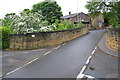
Railway bridge, Pottery Lane
The bridge has Network Rail designation TJC3/239
Image: © Roger Templeman
Taken: 30 May 2013
0.05 miles
8
Woodlesford Methodist Church - Church Street
Image: © Betty Longbottom
Taken: 11 Jun 2008
0.06 miles
9
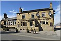
The Two Pointers public house, Church Street
The name refers to two Pointer dogs.
Image: © Mike Kirby
Taken: 16 Apr 2014
0.06 miles
10
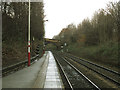
Woodlesford station, looking west
Woodlesford seems always to have had staggered platforms since its opening in 1840. This is the view down the line towards Leeds, with Pottery Lane bridge in the background.
Image: © Stephen Craven
Taken: 7 Dec 2016
0.06 miles