IMAGES TAKEN NEAR TO
Fleet Lane, LEEDS, LS26 8NX
Introduction
This page details the photographs taken nearby to Fleet Lane, LS26 8NX by members of the Geograph project.
The Geograph project started in 2005 with the aim of publishing, organising and preserving representative images for every square kilometre of Great Britain, Ireland and the Isle of Man.

There are currently over 7.5m images from over14,400 individuals and you can help contribute to the project by visiting https://www.geograph.org.uk
Image Map
Images are licensed for reuse under creativecommons.org/licenses/by-sa/2.0
Notes
- Clicking on the map will re-center to the selected point.
- The higher the marker number, the further away the image location is from the centre of the postcode.
Image Listing (23 Images Found)
Images are licensed for reuse under creativecommons.org/licenses/by-sa/2.0
Image
Details
Distance
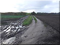
3
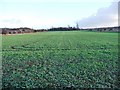
An orderly field of brassicas
In the corner formed by Eshald Lane and Fleet Lane.
Image: © Christine Johnstone
Taken: 9 Jan 2011
0.11 miles
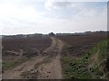
4
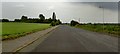
Fleet Lane
Extra wide road that rapidly narrows en route to the canal.
Image: © Steve Fareham
Taken: 30 May 2008
0.12 miles
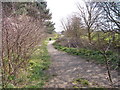
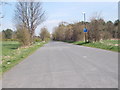
5
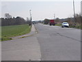
Fleet Lane - viewed from Eshald Lane
Image: © Betty Longbottom
Taken: 8 Apr 2015
0.13 miles
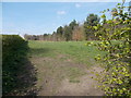
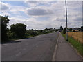
8
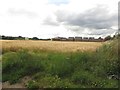
Arable field on the edge of Oulton
Looking across a field of barley to a new housing development on the edge of Oulton.
Image: © Graham Robson
Taken: 3 Aug 2015
0.15 miles