IMAGES TAKEN NEAR TO
Farrer Lane, LEEDS, LS26 8JP
Introduction
This page details the photographs taken nearby to Farrer Lane, LS26 8JP by members of the Geograph project.
The Geograph project started in 2005 with the aim of publishing, organising and preserving representative images for every square kilometre of Great Britain, Ireland and the Isle of Man.

There are currently over 7.5m images from over14,400 individuals and you can help contribute to the project by visiting https://www.geograph.org.uk
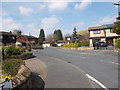
Image Map
Images are licensed for reuse under creativecommons.org/licenses/by-sa/2.0
Notes
- Clicking on the map will re-center to the selected point.
- The higher the marker number, the further away the image location is from the centre of the postcode.
Image Listing (121 Images Found)
Images are licensed for reuse under creativecommons.org/licenses/by-sa/2.0
Image
Details
Distance

2
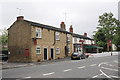
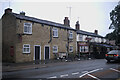
New Masons Arms, Aberford Road
There is an OS benchmark Image on the base corner stone on the front of the near corner of the pub
Image: © Roger Templeman
Taken: 30 May 2013
0.04 miles
3
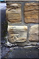
Benchmark on New Masons Arms
Ordnance Survey cut mark benchmark described on the Bench Mark Database at http://www.bench-marks.org.uk/bm49010
Image: © Roger Templeman
Taken: 30 May 2013
0.04 miles
4

The stream in the garden
This is Oulton Beck, and the little bridge is on the Ordnance Survey map!
Image: © Bob Harvey
Taken: 30 Sep 2021
0.05 miles
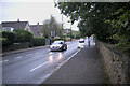
5
The New Masons
There are two pubs in Oulton called the Masons Arms. The New Masons and the Old Masons. This is the New Masons, and is around 130 years older than the Old Masons.
Image: © Bob Harvey
Taken: 30 Sep 2021
0.05 miles
6
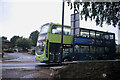
Catching the bus
I had booked into my room at the pub, and set out to photograph Oulton in the dusk, and just managed to catch a shot of this bus.
This is a Volvo B5LH Wright Eclipse Gemini 2, YJ13FKF, a hybrid diesel-battery bus operating as Arriva fleet number 1706 from Wakefield, on the 446 service ro Leeds city square to Wakefield bus station.
Image: © Bob Harvey
Taken: 30 Sep 2021
0.05 miles
8
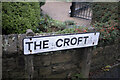
Road name
The road name for Image The postcode prefix LS26 has faded badly
Image: © Bob Harvey
Taken: 30 Sep 2021
0.06 miles