IMAGES TAKEN NEAR TO
Castle Lodge Square, LEEDS, LS26 0ZG
Introduction
This page details the photographs taken nearby to Castle Lodge Square, LS26 0ZG by members of the Geograph project.
The Geograph project started in 2005 with the aim of publishing, organising and preserving representative images for every square kilometre of Great Britain, Ireland and the Isle of Man.

There are currently over 7.5m images from over14,400 individuals and you can help contribute to the project by visiting https://www.geograph.org.uk
Image Map
Images are licensed for reuse under creativecommons.org/licenses/by-sa/2.0
Notes
- Clicking on the map will re-center to the selected point.
- The higher the marker number, the further away the image location is from the centre of the postcode.
Image Listing (45 Images Found)
Images are licensed for reuse under creativecommons.org/licenses/by-sa/2.0
Image
Details
Distance
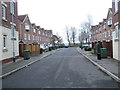
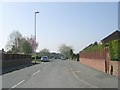
3
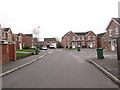
Castle Lodge Mews - St George's Park
Image: © Betty Longbottom
Taken: 25 Feb 2014
0.05 miles
5
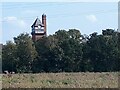
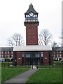
St George's Tower, Rothwell
The water tower, with clock and adjacent chimney, of the former St George's hospital. The hospital was built as the Hunslet Union Workhouse and Infirmary for the Rothwell, Methley and Hunslet Joint Isolation Hospital Committee. Architect Edward Dodgshun. The foundation stone is dated 8 November 1900 (there is a photo of it on Wikimedia Commons) and the hospital opened in 1903. It became St George's Hospital in 1934, later passing to the control of the NHS. It closed on 8th December 1991. The tower stood between the two main blocks of the hospital, which have since been demolished and replaced by modern housing. The tower itself has been converted to apartments and is listed grade II (list entry 1313183). See Image for a closer look.
This is just speculation, but as it is in the heart of the former coal mining area, I wonder if the hospital was built for, or mainly populated by, ex-miners suffering from the chronic lung diseases to which they were prone?
Source: https://www.nationalarchives.gov.uk/hospitalrecords/details.asp?id=1209
Image: © Stephen Craven
Taken: 9 Sep 2023
0.05 miles
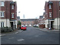
7
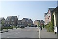
Castle Lodge Way - St George's Park
Image: © Betty Longbottom
Taken: 25 Feb 2014
0.07 miles
8
Castle Lodge Avenue - St George's Park
Image: © Betty Longbottom
Taken: 25 Feb 2014
0.07 miles
10
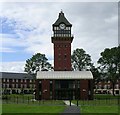
Clock Tower of the old Workhouse - Wood Lane
The Workhouse site is now a housing development known as St George's Park. The old clock tower has been preserved.
Image: © Betty Longbottom
Taken: 27 Jul 2007
0.08 miles